27.06.2019 Schauer- und Gewitterthread
Verfasst: Donnerstag 27. Juni 2019, 12:53
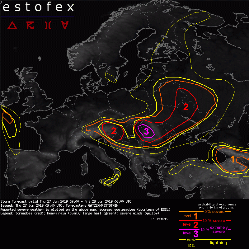
Ab dem Nachmittag bis in die erste Nachthälfte hinein können heute einzelne heftige Gewitter entstehen. Estofex hat heute Level 2 für die Osthälfte Österreichs ausgegeben:
Quelle: http://www.estofex.org/Storm Forecast
Valid: Thu 27 Jun 2019 09:00 to Fri 28 Jun 2019 06:00 UTC
Issued: Thu 27 Jun 2019 09:40
Forecaster: GATZEN/PISTOTNIK
...
Level 1 and 2 areas are issued for parts of Belarus, SW-most Russia, the Ukraine, Moldova, Romania, Slovakia, Hungary, Serbia, Bosnia-Herzegovina, Croatia, Slovenia and Austria mainly for large hail and to a lesser degree severe convective wind gusts and excessive convective precipitation.
...
SYNOPSIS
A high across northern Africa extends over France and ridges into the British Isles. At its western flank, a highly amplified trough is situated west of Europe. A plume of very warm, well-mixed air had spread into east Iberia, most of France, the Bay of Biscay, and southern British Isles. Another trough across Scandinavia amplifies over eastern Europe, associated with intense cold air advection over large portions of Europe. A frontal boundary extends from northern France to southern Germany, Hungary, and across the Ukraine and east Belarus, where a surface low moves east. Rich low-level moisture along this frontal boundary overlaps with steep lapse rates especially from France to Romania, where high CAPE develops. Finally, a weak trough is situated from Turkey to the south Mediterranean.
DISCUSSION
...from Romania to Austria and the north Balkans...
The cold front of the low across east Belarus moves southward today. Ahead of the front, abundant low-level moisture is present. Latest observations (Thu 08 UTC) confirm 2m dewpoints often between 20 and 23C over Hungary and surroundings. Aided by fairly steep lapse rates aloft and strong daytime heating, high CAPE between 2000 and 4000 J/kg is about to build.
A small but pronounced vorticity maximum overspreads the cold front during peak heating hours. Around 12 UTC, scattered convective initiation becomes likely along the cold front, especially where orography helps (e.g. over the north Carpathians, Tatras and eastern Alps). Under 0-6 km shear between 15 and 20 m/s and mostly unidirectional wind profiles, splitting supercells are the expected primary storm mode and have a high potential to produce large hail. A few cases of very large hail (>5 cm) are well possible. In addition, fairly deep subcloud layers promote a risk of severe downbursts which might turn extreme (>32 m/s) as well, especially in case upscale growth takes places. The latter scenario appears most likely from easternmost Hungary into western Romania, and these areas are therefore upgraded to a level 3, whereas stronger capping and somewhat weaker lift make it less likely over the eastern Alps.
Storms will gradually cluster towards evening and will move southeastward into larger parts of Romania, Serbia, Croatia and Slovenia. Storms will gradually become elevated after sunset and the severe weather risk starts to decrease, but large hail, severe wind gusts and excessive precipitation are still possible into the first half of the night.
...
