Deutschland: Tornado verwüstet Campingplatz!

Wetterinfos aus aller Welt
Benutzeravatar
Matthias
Beiträge: 6569
Registriert: Sonntag 19. April 2009, 19:43

Montag 12. Juli 2010, 19:31

Quelle: news.orf.at
Deutschland: Tornado verwüstete Campingplatz

Ein Tornado hat auf der deutschen Badeinsel Helgoländer Düne nach Angaben der Feuerwehr heute elf Menschen verletzt.
"Sie trugen größtenteils Knochenbrüche davon", teilte ein Sprecher in Pinneberg mit.

Der Tornado zerstörte fast alle Zelte auf dem Campingplatz der Insel.
Zu diesem Zeitpunkt waren etwa 100 Menschen auf dem Zeltplatz.
Nach dem Abklingen des Sturms wurden die Unverletzten mit Booten von der Düne zur Hauptinsel gebracht und dort vorübergehend in einer Schule untergebracht.

Gewitter und Sturmböen
Gewitter mit Sturmböen wüteten auch über West- und Norddeutschland und bescherten den Rettungskräften Hunderte Einsätze.
Laut Polizei wurde im niedersächsischen Nordhorn eine 47-Jährige von einem umstürzenden Baum erschlagen.
Vielerorts wurden laut Polizei Dächer abgedeckt, Bäume entwurzelt und Menschen von umherfliegenden Gegenständen verletzt.
Weitere Links:
http://www.rtl.de/medien/information/rt ... cf53127896" onclick="window.open(this.href);return false;
Bild

Quelle: http://www.heute.de/ZDFheute/inhalt/6/0 ... 86,00.html" onclick="window.open(this.href);return false;
Zelte "plattgemacht"

Der Tornado sei von Südwesten über den Platz gerast und habe in seiner Schneise etwa 80 bis 85 Prozent der rund 100 Zelte "plattgemacht", berichteten Camper. Am Südstrand seien Menschen durch umstürzende Strandkörbe verletzt worden. "Einige standen unter Schock." Der Wirt des Dünenrestaurants, Lutz Hardersen, berichtete von Strandkörben, die 100 Meter weit durch die Luft gewirbelt und völlig zerstört wurden.

Feuerwehr und Rettungskräfte waren im Einsatz, Bürgermeister Frank Botter löste den Katastrophenfall aus und forderte Hilfe vom Festland an. Augenzeugen berichteten von umgestürzten Flugzeugen auf dem Helgoländer Flugplatz. Die Hauptinsel blieb verschont.
Zuletzt geändert von Matthias am Montag 12. Juli 2010, 19:34, insgesamt 1-mal geändert.
lg,
Matthias

8072 Fernitz-Mellach, Graz-Umgebung

Wetterstation Fernitz: http://www.awekas.at/de/instrument.php?id=14717
Benutzeravatar
Gerald
Beiträge: 3218
Registriert: Mittwoch 25. März 2009, 14:57
Wohnort: 8553 Soboth

Montag 12. Juli 2010, 19:33

Obortig.... USA-Style....
Standort:
Lannach
Hannes
Beiträge: 9616
Registriert: Sonntag 19. April 2009, 21:30
Wohnort: Kötschach-Mauthen 705m ü. Adria Bezirk Hermagor,Oberes Gailtal

Montag 12. Juli 2010, 19:51

Oida fux Wüld...
lg Hannes
------------------------------------------------------
Wetterstation: Vantage Pro 2 Aktiv, Hellmann 200cm² Webcam Mobotix
Standort [ x ] Kötschach-Mauthen 705m.ü.Adria / Bezirk Hermagor/Oberes Gailtal
Standort [ ] Graz Eggenberg
Standort [ ] Miesenbach bei Birkfeld
Benutzeravatar
Mulvane
Beiträge: 1484
Registriert: Sonntag 16. Mai 2010, 16:15
Wohnort: Feldkirchen/Ktn. (580m)

Montag 12. Juli 2010, 19:56

Bist du gscheit! Schaut oba hammermäßig aus des Bild. *ja*
Schöne Grüße aus dem Süden.
Hele *wink* Feldkirchen/Ktn. ca.580m
Benutzeravatar
steirerbua
Beiträge: 2261
Registriert: Montag 20. April 2009, 11:14
Wohnort: Wagenbach bei Ebersdorf 8273(Bez.Hartberg)
Kontaktdaten:

Montag 12. Juli 2010, 20:09

einfach nur fett, endgeil!
lg Klaus

Wagenbach/Ebersdorf (Oststmk), 354m
Davis Vantage Pro 2

http://die-gute-alte-zeit.at
Eschi Seebr Chiemsee
Beiträge: 668
Registriert: Donnerstag 11. Februar 2010, 21:23
Wohnort: Seebruck, Chiemsee
Kontaktdaten:

Montag 12. Juli 2010, 20:14

Das ist auch genial: Bild.de
Seebruck, Chiemsee, 524 m
Wetterstation Seebruck
http://www.wetter-hausruckviertel.at/we ... start.html" onclick="window.open(this.href);return false;
Cams:
http://www.wetter-hausruckviertel.at/we ... bruck2.jpg" onclick="window.open(this.href);return false;
http://www.wetter-hausruckviertel.at/we ... ebruck.jpg" onclick="window.open(this.href);return false;
Chrisi95
Beiträge: 3759
Registriert: Freitag 24. Juli 2009, 22:30
Wohnort: Neudorf/Passail

Montag 12. Juli 2010, 21:25

*schock* *schock* *schock*
Neudorf/Passail 810m (Bez. Weiz), Grazer Bergland
Benutzeravatar
ThomasWWN
Beiträge: 6314
Registriert: Sonntag 19. April 2009, 21:31
Skype: thomaswwn
Rufzeichen: OE3STF
Wohnort: wochentags: 1030 Wien, Wochenende: 2603 Felixdorf
Kontaktdaten:

Montag 12. Juli 2010, 21:28

Hoffentlich gibts davon noch weitere Bilder. Konnte im Moment jedoch nichts finden.
ESWD | Weitere Funktion: ESWD User Support bei European Severe Storms Laboratory (ESSL)
ESSL > ESWD
Wetterstation 1030 Wien: https://www.ecowitt.net/home/index?id=79484
Chattiger

Montag 12. Juli 2010, 21:33

Das ist mal wieder ein schönes Indiz dafür das sich das Klima so derart verändert das wir in Europa immer mehr auf Amerikanische Wetterverhältnisse stoßen, und damit rechnen müssen.
Benutzeravatar
ThomasWWN
Beiträge: 6314
Registriert: Sonntag 19. April 2009, 21:31
Skype: thomaswwn
Rufzeichen: OE3STF
Wohnort: wochentags: 1030 Wien, Wochenende: 2603 Felixdorf
Kontaktdaten:

Montag 12. Juli 2010, 21:39

Chattiger hat geschrieben:Das ist mal wieder ein schönes Indiz dafür das sich das Klima so derart verändert das wir in Europa immer mehr auf Amerikanische Wetterverhältnisse stoßen, und damit rechnen müssen.
Würde ich nicht sofort in den "Klimawandel Topf" werfen.

Denn:

- Derzeit ist noch keine Stärke des Tornados bekannt (Schadensanalyse ausständig)

- Das Norddeutsche Küstengebiet gehört europaweit zu den "Hot Spots" was die Tornadodichte angeht

- Dass es der Tornado erst in die Medien geschafft hat, "verdanken" wir dem unglücklichen Umstand, dass er direkt über genutztes Insel-Gebiet gezogen ist. Ein paar hundert Meter von der Küste entfernt über dem Meer, und kein Hahn würde in den Medien danach schreien (was klar ist, angesichts der doch recht großen Häufigkeit von Tornados in diesem Gebiet).
ESWD | Weitere Funktion: ESWD User Support bei European Severe Storms Laboratory (ESSL)
ESSL > ESWD
Wetterstation 1030 Wien: https://www.ecowitt.net/home/index?id=79484
Chattiger

Montag 12. Juli 2010, 22:12

In Baden Würrtemberg ist aber auch einer gesichtet worden, wobei die dort nicht ganz so häufig auftreten.
Exilfranke1

Montag 12. Juli 2010, 22:18

hat nichts, aber auch gar nichts mit dem klimawandel zu tun !!

ich empfehle http://www.tordach.org/de/raw/TorDACH_de_v1600qc.txt" onclick="window.open(this.href);return false; als lektüre.
Benutzeravatar
everest65
Beiträge: 91
Registriert: Sonntag 28. Juni 2009, 15:24
Skype: adventure-austria
Wohnort: Stössing
Kontaktdaten:

Montag 12. Juli 2010, 22:21

beeindruckende, beängstigende und faszinierende Wolkenfotos!
Ich bin mir nicht im Klaren, wie ich auf Helgoland bei dem Anblick reagiert hätte.
Vielleicht: Schnell Fotos machen und dann mit Sauerstoffflasche eingraben... *geheim* ;)
LG. Martin

Stössing, 320 m - an Hegerberg

http://adventure-austria.deviantart.com/gallery/
Benutzeravatar
Stoney
Beiträge: 640
Registriert: Mittwoch 22. April 2009, 08:44
Skype: oe1ssu
Rufzeichen: OE1SSU
Wohnort: Wien
Kontaktdaten:

Dienstag 13. Juli 2010, 08:12

Bild

A level 3 for severe wind gusts, tornadoes, large hail and excessive precipitation was issued for eastern Netherlands, northwestern and northern Germany, and southwestern Denmark.


Bild
Wie hier in Düsseldorf waren starke Windböen mit rotierenden Wolkenformationen, Platzregen und sogar Hagel zu sehen.

Bild
Auf diesem Bild ist ganz deutlich zu sehen, wie größere Gegenstände einfach durch die Luft gewirbelt werden. Der Himmel ist stahlgrau.

Bild
Bild
Bild

Quelle:http://www.rp-online.de/panorama/deutsc ... 81011.html
lg Stefan,
Standort Wien 23 - Wetter: http://www.qth.at/oe1ssu/
Standort Niederösterreich, Kaiserkogel - Wetter + Webcam: http://adl304.oevsv.at/opencms/Wetter/
Benutzeravatar
Stoney
Beiträge: 640
Registriert: Mittwoch 22. April 2009, 08:44
Skype: oe1ssu
Rufzeichen: OE1SSU
Wohnort: Wien
Kontaktdaten:

Dienstag 13. Juli 2010, 08:14

Bild

quelle: rp-online.de

edit (Mathias): bitte keine Bilder ohne Quellenangaben verlinken!!
lg Stefan,
Standort Wien 23 - Wetter: http://www.qth.at/oe1ssu/
Standort Niederösterreich, Kaiserkogel - Wetter + Webcam: http://adl304.oevsv.at/opencms/Wetter/
Benutzeravatar
Cyver
Beiträge: 165
Registriert: Dienstag 2. Juni 2009, 17:27
Skype: Neoforever
Wohnort: Weinstadt Langenlois
Kontaktdaten:

Dienstag 13. Juli 2010, 08:19

Bist du moped ... *schock* .. Es stellt sich zwangsläufig die Frage ob diese Auswüchse des Wetters noch normal sind bzw. im normalen Zyklus kommen ..
Schöne Grüße aus

[x] Langenlois (NOE) [ ] Wien (W)

Ausrüstung: Nikon D90 Double VR Kit 18-105 + 70-300
Meine Gallery: http://www.stormhunter.at
Gerhard-Villach
Beiträge: 1780
Registriert: Sonntag 7. Juni 2009, 19:33
Kontaktdaten:

Dienstag 13. Juli 2010, 09:03

Es gibt scheinbar noch keine Hinweise auf einen Tornado.
Dürfte eher ein downburst gewesen sein, auch von den Fotos her!

mfg Gerhard
Der Weg zu den Quellen führt gegen den Strom!
Speedfreak
Beiträge: 383
Registriert: Freitag 22. Mai 2009, 11:26
Skype: Rocknrollattack
Kontaktdaten:

Dienstag 13. Juli 2010, 09:09

Holy Cow! *schock* Do is gscheit niedagangen..
A Video dazu gibs a scho:

http://www.youtube.com/watch?v=TMKmqrtOvrU" onclick="window.open(this.href);return false;
Standort: Fohnsdorf 736m
Bez.Judenburg/Oberstmk
(N 47° 12' 30", E 14° 40' 46")
http://www.ff-fohnsdorf.at" onclick="window.open(this.href);return false;
sindarella
Beiträge: 392
Registriert: Freitag 22. Mai 2009, 07:48
Wohnort: Neunkirchen
Kontaktdaten:

Dienstag 13. Juli 2010, 09:40

boa das video ist krass

bei dem unwetter fahren und gleichzeitig filmen und dokumentieren find ich allerdings mehr gefährlich als sonstwas
liebe grüsse aus neunkirchen (stadt) im südl NÖ
Speedfreak
Beiträge: 383
Registriert: Freitag 22. Mai 2009, 11:26
Skype: Rocknrollattack
Kontaktdaten:

Dienstag 13. Juli 2010, 09:49

Da geb ich dir absolut Recht. An Unfall herausfordern muass ma net unbedingt... *flop*
Standort: Fohnsdorf 736m
Bez.Judenburg/Oberstmk
(N 47° 12' 30", E 14° 40' 46")
http://www.ff-fohnsdorf.at" onclick="window.open(this.href);return false;
Benutzeravatar
Robert83
Beiträge: 8979
Registriert: Dienstag 21. April 2009, 10:44
Skype: mcrob83
Wohnort: St.Marienkirchen/Polsenz/ Bezirk Eferding/OÖ
Kontaktdaten:

Dienstag 13. Juli 2010, 10:03

Der Typ hat a Masn ghobt, dass a nicht a paar Kilometer weiter vorne war, sonst hättn vermutlich a Baum geküsst.
Generell: solche Fahrten im dichten Verkehr sind extrem riskant und ich vermeide so etwas tunlichst.
Die Kamera kleb ich mir aufs Amaturenbrett, dann hat man beide Hände zum Fahren frei.
Bei so einer Wetterlage such ich mir eher einen Spotterplatz und was ordentliches zum Unterstellen, dann kann man selbst die kräftigste Zelle wunderbar genießen.
Benutzeravatar
Stoney
Beiträge: 640
Registriert: Mittwoch 22. April 2009, 08:44
Skype: oe1ssu
Rufzeichen: OE1SSU
Wohnort: Wien
Kontaktdaten:

Dienstag 13. Juli 2010, 10:06

sindarella hat geschrieben:boa das video ist krass

bei dem unwetter fahren und gleichzeitig filmen und dokumentieren find ich allerdings mehr gefährlich als sonstwas
Habe ich einen Lösungsvorschlag - gefahrlos Filmen beim Auto- und Fahrradfahren uvm.
http://www.skywarn.at/forum/viewtopic.php?f=42&t=5525" onclick="window.open(this.href);return false;
lg Stefan,
Standort Wien 23 - Wetter: http://www.qth.at/oe1ssu/
Standort Niederösterreich, Kaiserkogel - Wetter + Webcam: http://adl304.oevsv.at/opencms/Wetter/
Hannes
Beiträge: 9616
Registriert: Sonntag 19. April 2009, 21:30
Wohnort: Kötschach-Mauthen 705m ü. Adria Bezirk Hermagor,Oberes Gailtal

Dienstag 13. Juli 2010, 11:31

Puhhh heftigst ist da zur Sache gegangen *schock*
lg Hannes
------------------------------------------------------
Wetterstation: Vantage Pro 2 Aktiv, Hellmann 200cm² Webcam Mobotix
Standort [ x ] Kötschach-Mauthen 705m.ü.Adria / Bezirk Hermagor/Oberes Gailtal
Standort [ ] Graz Eggenberg
Standort [ ] Miesenbach bei Birkfeld
Benutzeravatar
Stoney
Beiträge: 640
Registriert: Mittwoch 22. April 2009, 08:44
Skype: oe1ssu
Rufzeichen: OE1SSU
Wohnort: Wien
Kontaktdaten:

Donnerstag 15. Juli 2010, 08:01

Erneut -

Bild

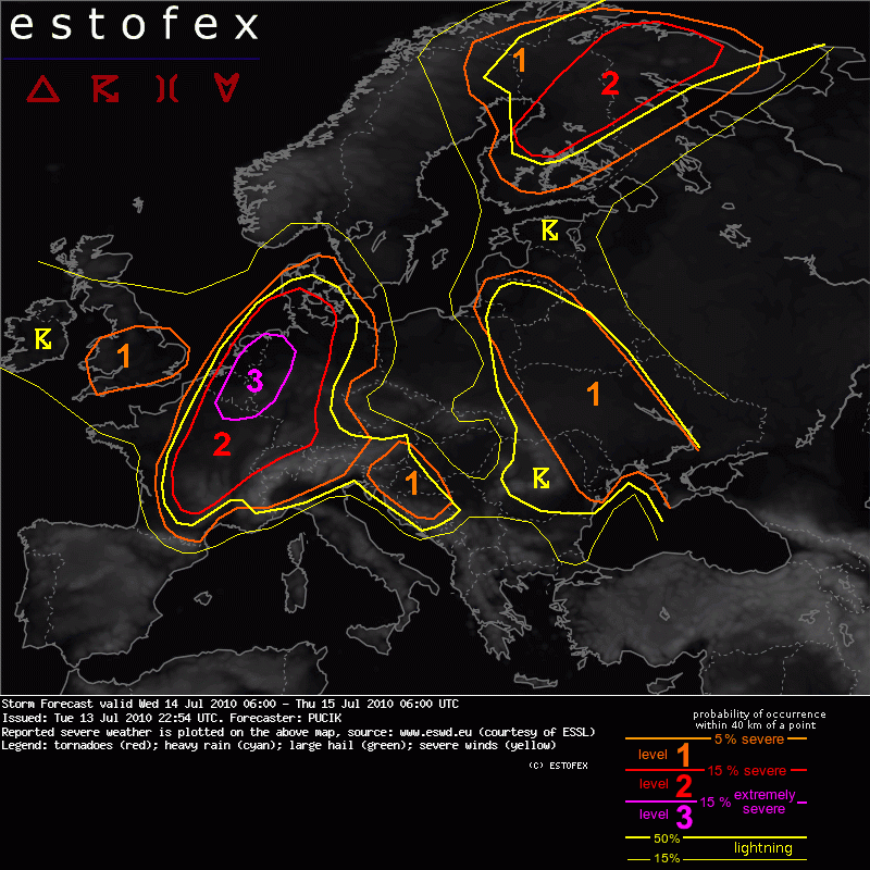
A level 3 was issued for Benelux, small area of Northern France and extreme Northwestern Germany mainly for severe wind gusts, tornadoes, excessive precipitation and large hail.


SYNOPSIS

The main macro-synoptic feature at mid levels will be a trough with axis over the Eastern Atlantic, with an embedded cold-core low centered over Ireland by Wednesday 12 UTC, moving slowly to northeast. Strong flow surrounds the fringes of the trough with windspeeds up to 40 m/s at 500 hPa level. A short wave trough will translate with this flow in the evening and early night hours over Northern France, Benelux countries towards Scandinavia. To east, a large ridge will stretch from the Central Mediterranean, across much of Central Europe into Northwestern Russia.

At the surface a centre of the deep low will reside close to or over the British Isles. Its trough will extend with the frontal system to the southeast and will accelerate quickly eastwards during the day. Mesoscale low will probably form within the frontal wave over Benelux and might become a significant factor in scenario. Ahead of the frontal system, high Theta-E airmass is advected at lower levels to northeast.


DISCUSSION

... France, Benelux, Western half of Germany ...

***Potentially dangerous setup with severe weather outbreak is forecast over this region***

Ahead of the frontal zone, high Theta-E airmass is advected at lower levels and as cooler mid-level temperatures overspread this airmass a belt of moderate latent instability is forecast to form. Models are in fairly good agreement regarding the CAPE values, which should be mostly in the range of 1000-1500 J/kg.

With strong southerly to southwesterly flow aloft, high values of wind shear are forecast, with over 25 m/s of DLS and 20 m/s of MLS, values sufficient for very well organised convection, including supercells. With weak relative upper level flow, convection will probably tend to organise into quasi-linear system rathern than into long-lived supercells. Another factor speaking for such system is the orientation of the mid and upper level flow to the boundary, which is almost parallel and therefore, quick clustering is expected. Nevertheless, the possibility of isolated, steadier supercellular convection, especially in the earlier stages of scenario can not be discounted.

Forcing should be very favorable, in the form of the cold front and as the above mentioned short wave trough , which might induce or support cyclogenesis in the axis of the frontal trough. Such low would probably contribute to the backing of the surface winds (increasing SREH values) ahead of it and to the strenghtening wind field at lower levels. Models simulate 30 m/s 700 hPa flow during evening and night hours in the proximity and behind of the surface front.

With such strong wind field at lower levels, quickly travelling mid-level short wave trough and strong tendency for storm clustering, severe quasi-linear MCS might travel at high speeds to northeast along the front and produce a swath of severe wind gusts, including some gusts over 32 m/s. This will be the prime threat and Level 3 is issued especially for the area, where the passage of severe MCS is most probable. In the earlier stages, when isolated form of convection will prevail and over the southern parts of Level 2, large hail will be a threat, especially if supercells form. In that case, hailstones over 4 cm might be observed. Especially to the northwest of the mesoscale low, excessive precipitation might occur, at the northern end of large MCS with possibility of "train effect". With high effective PW values, at least short term excessive precipitation can not be ruled out elsewhere in Level 2. Last, but not least, tornadoes might occur and more so in the environemnt with higher SREH and LLS ahead of the mesoscale low and lower LCLs during the late evening and night hours - therefore BENELUX and Northwestern Germany will probably be the region with the highest probability of tornado occurence. The fact that the convection will tend to occur mostly in linear clusters limits the potential for tornadoes


...Eastern Germany, Northern Denmark, Alpine region...

As front progresses eastwards during the night hours, instability will diminish and become likely elevated but a slight chance for severe weather will still exist, especially as strong low level wind field will remain immediately behind the cold front.

To the south, isolated to scattered convection might form over Alpine region during the day and in moderate wind shear and instability, isolated large hail or isolated event of excessive precipitation is not ruled out.
lg Stefan,
Standort Wien 23 - Wetter: http://www.qth.at/oe1ssu/
Standort Niederösterreich, Kaiserkogel - Wetter + Webcam: http://adl304.oevsv.at/opencms/Wetter/
Benutzeravatar
everest65
Beiträge: 91
Registriert: Sonntag 28. Juni 2009, 15:24
Skype: adventure-austria
Wohnort: Stössing
Kontaktdaten:

Donnerstag 15. Juli 2010, 11:40

Da gibts noch Fotos von der Zelle über Helgoland:
http://www.shz.de/artikelbilder.html?us ... ckpid%5D=0
*schock*
LG. Martin

Stössing, 320 m - an Hegerberg

http://adventure-austria.deviantart.com/gallery/
Antworten