

Den Thread werden wir heute noch brauchen. Heute wird der SO des Landes betroffen sein.
Bei uns gab es gegen 6 Uhr bereits einen kurzen, kräftigen Regenschauer.
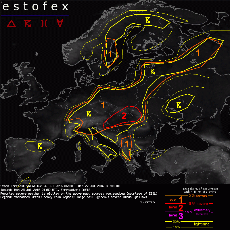
Link: http://estofex.org/estofex.org hat geschrieben:...
A level 2 was issued for parts of S Poland, Slovakia, Hungary, NE Croatia, SW Ukraine and NE Romania mainly for excessive precipitation.
A level 1 was issued for a large part of Central and East Europe mainly for excessive precipitation and large hail.
SYNOPSIS / DISCUSSION
The main feature visible at the upper level maps is wide meso-low over between Iceland and Norway, which is associated with many smaller disturbances, affecting mostly Norway and Sweden. Another cold bubble is found travelling from Adriatic Sea towards S Balkans were is expected to perish during Tuesday. On the surface, the cold front of the low pressure system north from the UK, will cross parts of Germany, Norway and Sweden. The biggest part of the continent will experience DMC as weak flow and very moist PBL create ideal conditions for excessive precipitation events. Mid-level lapse rates and DLS are weak almost everywhere inside the big level 1 area that we drew, but MLCAPE up to 2000 J/kg overlaps with very high PW in the range of 35-40 mm. We do not expect clustering of the storms, but single cells staying over an area could cause severe flash floods, especially in Hungary and West Ukraine. We forecast one or two large hail events in N Belarus and Russia as the PW load is less and CAPE reaches values of 2500 J/kg. Diurnal heating will be the steering mechanism of DMC but also noncturnal thunderstosms will pose a threat.
...


