Seite 1 von 1
16.02. - 17.02.2022 Sturmthread
Verfasst: Mittwoch 16. Februar 2022, 13:06
von Dustdevil
In der kommenden Nacht und morgen sorgt ein Tief mit Zentrum über Dänemark in Deutschland und weiten Teilen Österreichs für eine heftige Sturmlage. ESTOFEX hat für Teile Deutschlands sogar Level 3 ausgerufen. Der Höhepunkt wird dort in der zweiten Nachthälfte erwartet.
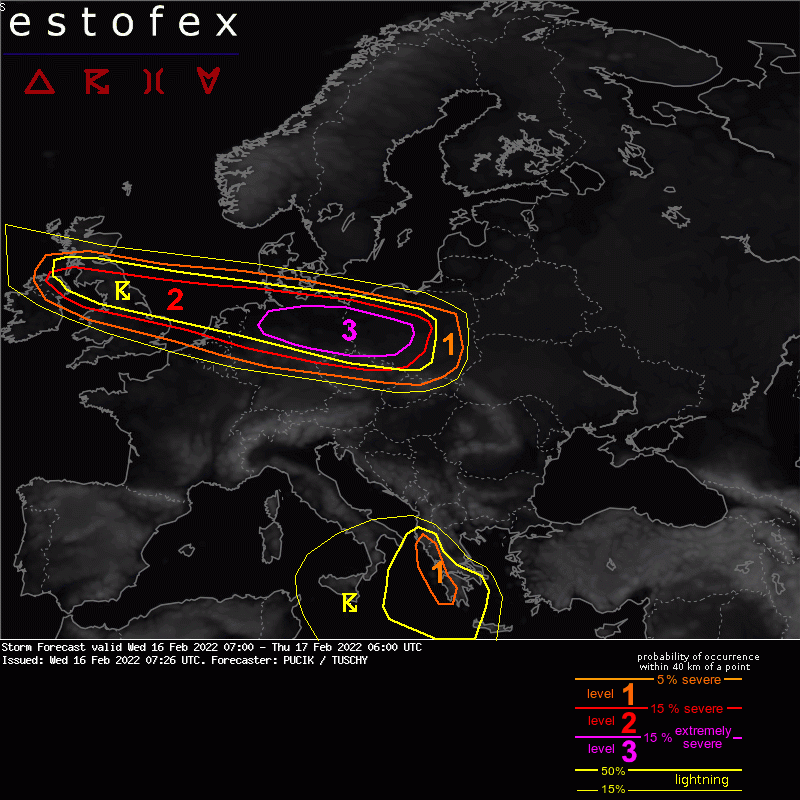
A level 3 was issued for N Germany and W Poland mainly for extremely severe wind gusts and tornadoes.
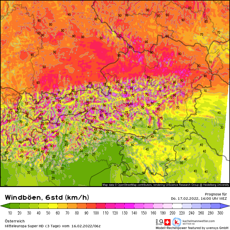
In Österreich sieht die Sache eine Spur weniger heftig aus, dennoch sind morgen vor allem um die Mittagszeit nördlich der Alpen verbreitet Böen von 80-100 km/h zu erwarten. In exponierten Lagen und in den Bergen ist auch mit Orkanböen zu rechnen. Vom Sturm größtenteils verschont bleibt der Süden.
Re: 16.02. - 17.02.2022 Sturmthread
Verfasst: Mittwoch 16. Februar 2022, 15:55
von Feli
gefällt mir echt ned, wenn das für meine normal sehr ruhige gegend so viel wind geben soll...
und dann freitag auf samstag nach sinds schon wieder rund 80 - 90 km/h
Re: 16.02. - 17.02.2022 Sturmthread
Verfasst: Mittwoch 16. Februar 2022, 23:32
von hhkes
Aktuell im Raum Graz verbreitet Windstille.
LG, Harald
Re: 16.02. - 17.02.2022 Sturmthread
Verfasst: Donnerstag 17. Februar 2022, 06:08
von Feli
da gibts was neues von estofex...
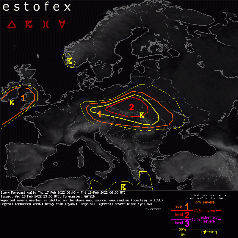
Storm Forecast
Valid: Thu 17 Feb 2022 06:00 to Fri 18 Feb 2022 06:00 UTC
Issued: Wed 16 Feb 2022 23:06
Forecaster: GATZEN
A level 2 was issued across southern Poland, north-eastern Czech Republic, northern Slovakia, and western Ukraine for severe wind gusts and to a lesser extent tornadoes.
A level 1 was issued across south-eastern Germany, northern Austria, northern Hungary, northern Romania, northern Modolva, and western Ukraine for wind gusts.
A level 1 was issued for Ireland, Wales, and western England for wind gusts.
SYNOPSIS
Strongly-forced synoptic situation continues on Thursday with an amplifying trough across Central Europe and strongly rising geopotential to its west in response to downstream development. A well-developed mid-level vorticity-maximum and tropopause fold crosses Poland towards the Ukraine and Black Sea. It affects a rather moist low-level air mass that can become unstable ahead of a cold front.
To the west, strong ridging takes place downstream of an intense north-Atlantic trough. Explosive cyclogenesis is expected to affect the British Isles on Friday morning.
Finally, the central Mediterranean cut-off trough is further digging south reaching northern Libya and Egypt where it will be associated with thunderstorms.
DISCUSSION
Strongly-forced synoptic situation continues on Thursday with an amplifying trough across Central Europe and strongly rising geopotential to its west in response to downstream development. A well-developed mid-level vorticity-maximum and tropopause fold crosses Poland towards the Ukraine and Black Sea. It affects a rather moist low-level air mass that can become unstable ahead of a cold front. To the west, strong ridging takes place downstream of an intense north-Atlantic trough. Explosive cyclogenesis is expected to affect the British Isles on Friday morning. Finally, the central Mediterranean cut-off trough is further digging south reaching northern Libya and Egypt where it will be associated with thunderstorms.
Ongoing high-shear, low-CAPE event is forecast on Thursday morning, with a line echo wave pattern travelling across southern Poland and northern Czech Republic and Slovakia. Due to initially rather rich low-level moisture, with mixing ratios in around 5 g/kg, and steepening lapse rates ahead of the cold front and close to the PV intrusion, marginal MLCAPE is forecast. This instability overlaps with 20 to 25 m/s low-level bulk shear and high storm-relative helicity.
Main threat is ongoing wind gust potential, in particular along bowing segments of the convective line. However, especially initially, a tornado threat exists where cloud bases are low and mesocyclones can develop.
On its way east, the PV intrusion will move into an area with decreasing low-level moisture. Potential for thunderstorms will therefore decrease due to weaker MLCAPE. However, current thinking is that the strongly-forced event is still accompanied by convective storms. While low-level vertical wind shear decreases, severe potential will also slowly diminish, with severe wind gusts the main threat until the afternoon, when instability across Belarus and Ukraine is expected to become zero.
Farther to the west and north, a few additional storms are forecast across SE Germany and N Poland. In the wake of the cold front, still strong vertical wind shear exists, but without strong low-level convergence, showers and thunderstorms will be rather weak and contribution to the wind gust threat is considerably lower compared to the frontal thunderstorms to the east.
British Isles
Model data suggests explosive cyclogenesis and an intense mid-level PV intrusion moving into the British Isles. Strong lift of a moist air mass will result in some steeper lapse rates and marginal CAPE is forecast.
Within the frontal rain band of the occlusion, isolated elevated thunderstorms are forecast. Along the occlusion and cold front, some surface-based storms are expected. Latest models indicate that the PV intrusion will be rather low, and storms will be low-topped. Therefore, lightning is a little bit uncertain at this time. However, if storms will form, they will enhance the wind gust threat that is already very high.
Re: 16.02. - 17.02.2022 Sturmthread
Verfasst: Donnerstag 17. Februar 2022, 07:51
von jfk
Hier ist's derzeit noch ruhig, mit Takt -0.5 C auch ziemlich kalt. In Deutschland, Polen und Tschechien gibt's gewittrige Aktivitäten!
Re: 16.02. - 17.02.2022 Sturmthread
Verfasst: Donnerstag 17. Februar 2022, 08:14
von Gernot33
Sehr starker und böiger Wind
Re: 16.02. - 17.02.2022 Sturmthread
Verfasst: Donnerstag 17. Februar 2022, 08:48
von hhkes
Weiterhin Windstille in weiten Teilen des SE.
LG, Harald
Re: 16.02. - 17.02.2022 Sturmthread
Verfasst: Donnerstag 17. Februar 2022, 10:54
von Feli
Einsätze laufender Tag (seit 00:00)
Einsätze: 192, Feuerwehren: 160 (alarmiert im Einsatz)
Re: 16.02. - 17.02.2022 Sturmthread
Verfasst: Donnerstag 17. Februar 2022, 11:17
von Feli
analyse SE von 10:00 Uhr - kachelmann
analyse OÖ von 10:00 uhr
Re: 16.02. - 17.02.2022 Sturmthread
Verfasst: Donnerstag 17. Februar 2022, 14:44
von hhkes
Im Raum Graz Wind aus südlichen Richtungen mit Spitzen um 25 km/h.
Takt um 20 C

LG, Harald
Re: 16.02. - 17.02.2022 Sturmthread
Verfasst: Donnerstag 17. Februar 2022, 14:51
von Feli
Re: 16.02. - 17.02.2022 Sturmthread
Verfasst: Donnerstag 17. Februar 2022, 15:03
von rudolf
Wir hatten von 10 Uhr bis 12 Uhr einen Stromausfall!
Re: 16.02. - 17.02.2022 Sturmthread
Verfasst: Donnerstag 17. Februar 2022, 15:39
von Robert83
In höheren Lagen gibts zurzeit ordentliche Orkanböen, am Mayrhofberg(654m) oberhalb des Eferdinger Beckens wurden vorhin 133,6km/h gemessen.
In Davidschlag bei Kirchschlag bei Linz konnten an der hiesigen Wetterstation gar 135km/h verzeichnet werden.
Das Maximum ist aber überschritten, vor allem in den Niederungen sind die Böen niedriger als am Vormittag,
auch interessant: das 10min Mittelmittel betrug vorhin 99km/h
Re: 16.02. - 17.02.2022 Sturmthread
Verfasst: Donnerstag 17. Februar 2022, 15:48
von Feli
rudolf hat geschrieben: ↑Donnerstag 17. Februar 2022, 15:03
Wir hatten von 10 Uhr bis 12 Uhr einen Stromausfall!
auch in der stadt steyr gabs keinen strom und in weiten teilen von SE
Re: 16.02. - 17.02.2022 Sturmthread
Verfasst: Donnerstag 17. Februar 2022, 16:10
von nuntius
hhkes hat geschrieben: ↑Donnerstag 17. Februar 2022, 14:44
Im Raum Graz Wind aus südlichen Richtungen mit Spitzen um 25 km/h.
Takt um 20 C
LG, Harald
Bis vor kurzem war der Wind aus S unter 10 km/h. Vorhin gab's "die erste Böe" mit 34 km/h aus SW.
Allerdings die Temperatur mit 18°C am frühen Nachmittag und noch aktuell 15°C bei strahlendem Sonnenschein (gefühlte Temperatur daher weitaus höher!).
Re: 16.02. - 17.02.2022 Sturmthread
Verfasst: Donnerstag 17. Februar 2022, 21:35
von Dustdevil
Da waren schon sehr heftige Böen dabei, leider auch einige Schäden und im Ausland auch Tote:
https://orf.at/stories/3247810/
Top 5 TAWES Windspitzen (<1000 m):
Buchberg (NÖ): 147,8 km/h
Leiser Berge (NÖ) 142,9 km/h
Jauerling (NÖ) 132,1 km/h
Wien Jubiläumswarte: 127,1 km/h
Enns (OÖ): 120,2 km/h
Auch temperaturtechnisch war der heutige Tag mit Höchstwerten von bis zu 22°C in Graz außergewöhnlich.
Hier in Kärnten war davon nicht viel zu merken. Der Wind wehte maximal mit 20 km/h, lediglich in einigen Tälern im Norden griff der Wind mit Böen bis zu 60 km/h durch.
Re: 16.02. - 17.02.2022 Sturmthread
Verfasst: Freitag 18. Februar 2022, 00:27
von hhkes
Auch im SE hat der Wind zeitweise durchgegriffen, hier z.B. gab es am Nachmittag eine Windspitze von 50 km/h, am Abend sogar 67 km/h.
LG, Harald, FG

