Seite 1 von 1
31.07.2024 Schauer- und Gewitterthread
Verfasst: Dienstag 30. Juli 2024, 22:21
von jfk
Weiter geht's... morgen sind Schauer und Gewitter im Westen zu erwarten:

++ Forecast – Kräftige Schauer und Gewitter im Westen am Mittwoch möglich – Erstellt: 30.07.2024 22:20 Uhr ++
Für die westlichen Teile von Tirol und das östliche Vorarlberg gilt eine orange Warnung (Stufe 2/4). Eine gelbe Warnung (Stufe 1/4) wurde für den gesamten umliegenden Westen Österreichs ausgegeben, einschließlich Osttirol, westlicher Teile von Kärnten, zentralem und nördlichem Salzburg sowie westlichem Oberösterreich.
Der Einfluss des Hochdruckgebiets lässt langsam nach, wodurch die Luftmassen wieder labiler werden. Eine zunehmend südwestliche Höhenströmung führt dazu, dass energiereiche Luftmassen angeführt werden. Am Mittwoch sind ab den Mittagsstunden im Westen Quellwolken zu erwarten, aus denen Schauer und Gewitter entstehen können. Diese ziehen von Südwesten nach Nordosten.
Die Gewitterzellen ziehen nach Bayern ab, könnten jedoch in der Nacht (vermutlich erst nach Mitternacht) noch Salzburg und westliches Oberösterreich erreichen. Die Warnung für diese Bereiche ist bis zum Ende der Wettervorhersage ab dem Abend gültig. Die höchste Wahrscheinlichkeit für schwere Wetterereignisse besteht im Bereich Innsbruck bis in die östlichen Gebiete von Vorarlberg (orange Warnung). Es besteht die Gefahr von lokalen Windböen, Hagel (lokal bis 4 cm möglich) sowie Starkregen mit möglichen lokalen Überschwemmungen.
Forecaster: Johannes Kahr (jfk)
Gültig von: 31.07.2024, 14:00 Uhr
bis: 01.08.2024, 02:00 Uhr
Erstellt: 30.07.2024, 22:20 Uhr
Re: 31.07.2024 Schauer- und Gewitterthread
Verfasst: Dienstag 30. Juli 2024, 22:23
von jfk
ESTOFEX Extended Forecast:
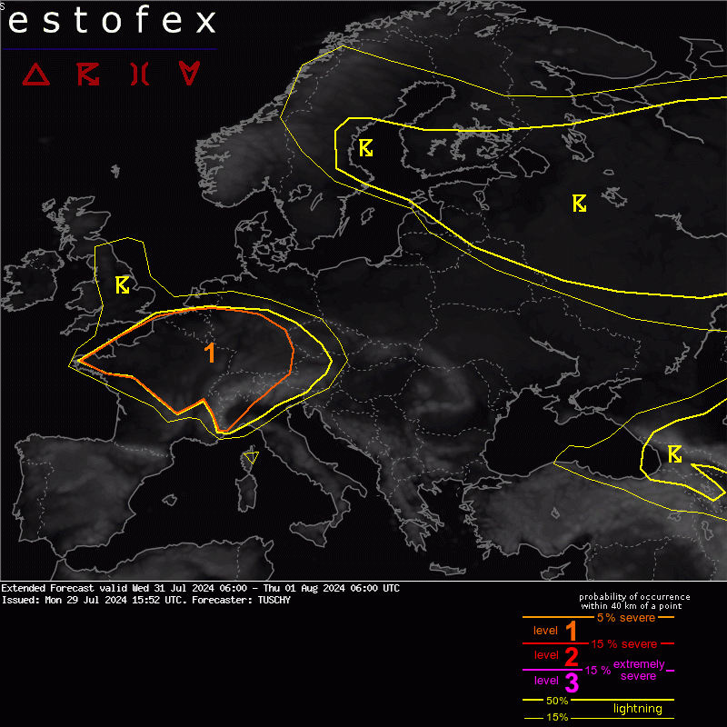
A level 1 was issued across parts of France, Belgium, Luxembourg, SW Germany, W Austria, NW Italy and Switzerland mainly for heavy/extreme rain, large to isolated very large hail and strong to severe downburst events.
Quelle: ESTOFEX (
https://www.estofex.org/)
Re: 31.07.2024 Schauer- und Gewitterthread
Verfasst: Mittwoch 31. Juli 2024, 10:30
von jfk
ESTOFEX Forecast (Update):

A level 2 was issued for N/E France into SW Germany, Switzerland and W Austria mainly for large to isolated very large hail (western part) and excessive rain.
A broad level 1 encompasses the level 2 area mainly for heavy to excessive rain. In addition a few large hail events are forecast next to regional swaths of severe gusts (SW Germany)
DISCUSSION
... France to Germany, Belgium, Luxembourg, Switzerland into N Italy ...
The plume of very moist air with TPWs in the 40-50 mm range (TPW anomalies of 150-200% to the climatology) and high BL moisture (Tds in the lower twenties with BL mixing ratios in the 14-16 g/kg range) spread E into Belgium/Luxembourg and W/SW Germany/Switzerland.
Not much convective modification occurred, so expect still rather healthy mid-level lapse rates of the Spanish/North African EML plume to overspread that BL moisture. The result will be MUCAPE values in the 1500-3000 J/kg range with higher peaks likely (e.g. yesterday's 12Z sounding from Trappes with 3500 J/kg MUCAPE). DLS remains weak (around 10 m/s), so convection should be pulsating.
Regarding timing and regional coverage of DMC activity there are still a lot of uncertainties left (e.g. from the previous night).
However some more coherent signals exist that a slowly E/NE ward moving pulsating cluster affects Belgium/Luxembourg during the morning as it rides along a diffuse/wavy warm front boundary. This convection probably builds an MCV, which reveals its structure during the convective minimum of the diurnal cycle. If this MCV verifies, this vortex could be the main focus for new development around noon/into the afternoon hours along its S/SE quadrant with convection pushing into W Germany later on, before weakening as it outruns the CAPE plume. Heavy rain will be the main hazard.
Otherwise the region just downstream of the mid-level wave and S of the MCV cloudiness will see a rapid uptick in CI during the afternoon, which would bring E-France / SW Germany into the focus. Intense pulsating convection grows upcale into numerous eastward moving clusters. Also, the orography of the Swiss Alps acts as focus for scattered/widespread CI, which could grow upscale into an extensive cluster. Ensemble data/simluated IR/WV data show a realistic chance for a cluster covering all of E-Switzerland/ W-Austria and SW-Germany during the evening hours into the overnight hours.
A manageable BL moisture depth over SW Germany/Switzerland is prone to diurnal mixing with 2m dewpoints dropping into the mid tens, yielding deep/well mixed low-tropospheric conditions (inverted-V profiles). Therefore there will be a risk for severe downbursts as thunderstorms move in from the W or develop on site. Severe gusts are also possible as upscale growing convection develops extensive cold pools. This scenario is covered in the ID2-EPS with a broad swath of Bft 8/9 gusts over SW into S-Germany and weaker signals for Bft 10/11 gusts.
Initiating convection also poses a large hail risk as top-down weighted CAPE profiles offset weak shear and even a very large hail event (in excess of 5 cm) is possible, especially in E France (Grand Est to Bourgogne-Franche-Comté region).
The main story however becomes the rain as very high rainfall rates are forecast with DMC activity. Flash flooding on the local scale is possible and as DMC interacts with the orography even a significant flash flood event is not ruled out with more than 40% probabilities for more than 40 l/qm/h along the cluster's path (W-Alps).
In addition, expected amount of latent heat release should induce another MCV feature somewhere over S/CNTRL Germany. Along its periphery, training convection becomes an issue as convective elements slow down due to modified SR winds. Latest data indicates the highest risk over CNTRL Germany but this remains uncertain. Nonetheless we expanded the level 1 well into E Germany to cover this option.
The cluster should weaken during the night as it outruns the instability axis but we could see an impact as far E as far SW Czechia/CNTRL Austria.
We upgraded parts of yesterdays SWODY 2 to a level 2 as confidence increased in a developing corridor with enhanced severe including a few extreme events (rain/hail).
During the night, the attention turns to the next wave and if CI occurs, an untouched airmass with MUCAPE in the 2000-3000 J/kg range interacts with regionally enhanced DLS along the wave's periphery (ID2 up to 15-20 m/s DLS). This would support another extensive cluster to impact most of N/NE France during the night. Large hail and flash flood producing excessive rain will be the main hazard next to strong/ isolated severe gusts. NWP guidance however diverges substantially with this activity.
Despite ongoing uncertainties in NWP guidance, we think that enough BL recovery (behind the nocturnal cluster and forenoon activity) exists for a high CAPE setup as the wave approaches. ID2 also constantly showed nice signals for active DMC initiation. The same for the ensemble data but also for models, which had the best handling with last nights convection over France. Hence a level 2 was added also for this area.
As a side-note: MCV driven shear can increase on a regional scale along its periphery, so we cannot rule out a few better organized storms next to the MCV track. Also, any developing cluster should produce an impressive amount of lightning with forecast CAPE/moisture distribution.
Finally, N-Italy will see weakly capped MUCAPE in the 2000-3000 J/kg range with near zero DLS (1-5 m/s). Latest NWP guidance keeps convection along the orography, but in case a cluster evolves we could see a strong outflow surging into the Piemonte/Lombardy area, supported by low probabilities in the ensemble data. We therefore expanded the level 1 a bit more S.
Slow moving convection poses a large hail and excessive rainfall threat on a local scale. Dependant on how extensive the Swiss/Austrian/German cluster will be, we could also see some issues with peripheral subsidence, affecting CI activity over NW Italy (negative).
Quelle: ESTOFEX (
https://www.estofex.org/)
Re: 31.07.2024 Schauer- und Gewitterthread
Verfasst: Mittwoch 31. Juli 2024, 16:07
von MeteoPit
Hallo und schönen Nachmittag
Hier in Vahrn kräftige Windböen
Es hat auch geplatscht….. Blitz und Donner sind auch dabei…..die Bedienung von der Bar musste schnell draußen alles wegräumen
Weiter Windböen
Aber sonst nichts markantes
Viele Grüße aus Vahrn bei Brixen
MeteoPit
Re: 31.07.2024 Schauer- und Gewitterthread
Verfasst: Mittwoch 31. Juli 2024, 19:09
von Feli
seit ca. 17 uhr gewitter in vorarlberg und tirol
so schauts aktuell aus
Re: 31.07.2024 Schauer- und Gewitterthread
Verfasst: Mittwoch 31. Juli 2024, 19:12
von Feli
livestream da sind die gewitter in Ö mit drinnen:
Hier erscheint normalerweise ein Video von YouTube. Bitte wende dich an einen Administrator.
Hier erscheint normalerweise ein Video von YouTube. Bitte wende dich an einen Administrator.
Re: 31.07.2024 Schauer- und Gewitterthread
Verfasst: Mittwoch 31. Juli 2024, 20:39
von Feli
die gewitter ziehen im norden von tirol weiter - grad nördlich von innsbruck ein recht blitzreiches gewitter
hier takt. 26,2°C - windstill - trocken - dünne wolken ziehen von westen her auf
Re: 31.07.2024 Schauer- und Gewitterthread
Verfasst: Mittwoch 31. Juli 2024, 20:45
von Feli
Unwetter: Murenabgang auf Arlbergstraße
ORF-Vorarlberg
https://vorarlberg.orf.at/stories/3267367/

Die Arlbergstraße zwischen Langen und Alpe Rauz ist nach einem Murenabgang gesperrt. Wegen Sanierungsarbeiten ist auch der Arlbergtunnel gesperrt. Ausweichen kann man nur großräumig über die L198 über Lech und in weiterer Folge über die L200. (Stand Mittwoch 21.00 Uhr)
quelle: Maurice Shourot

Re: 31.07.2024 Schauer- und Gewitterthread
Verfasst: Mittwoch 31. Juli 2024, 20:48
von jfk
Nach wie vor teils kräftige Schauer und Gewitter in Tirol. Lokale Gefahr durch Sturzfluten erhöht.
Re: 31.07.2024 Schauer- und Gewitterthread
Verfasst: Mittwoch 31. Juli 2024, 22:47
von gerhard
Im Vorfeld der Front aus Bayern kräftiger Wind
Re: 31.07.2024 Schauer- und Gewitterthread
Verfasst: Donnerstag 1. August 2024, 00:58
von KanatschnigHubert
jetzt bei mir auch lebhafter Wind um 45 - 50 km/h