Den werden wir heute brauchen, im Norden mehr, als im Süden. Dahingehend der Forecast von Estofex also auch hat Herfried einen Skywarn-Forecast erstellt.
Forecaster: Herfried Eisler
Gültig von:
bis: 23.05.2020 - 24:00 Uhr
Erstellt: 23.05.2020 - 07:55 Uhr
Der Weißwurstexpress fährt heute. Eine markante Kaltfront zieht im Tagesverkauf von West nach Ost durch, entlang der Alpennordseite ist dabei mit Gewittern zu rechnen. Diese werden häufig schwer ausfallen, angezrieben durch starken Wind in mittleren Höhen und mäßige Labilität, bringen schnell ziehende Gewitterlinien, Böenfrontrn, verbreitet Sturmböen, vereinzelt Orkanböen. Vorlaufene Gewitter können aus kurzlebige Mesozyklone und eher kleinen, intensiven Hagelschlag mit sich bringen.
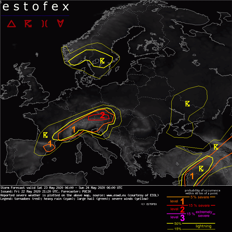
...A level 2 was issued across the northern Alpine rim mainly for damaging wind gusts and large hail.
A level 1 was issued in a belt from SE France through N Italy, Switzerland, SE Germany, Austria and SW Czech Republic mainly for severe wind gusts, large hail and excessive rainfall...
...
... SE France to SW Czech Republic ...
In conjunction with the approaching deep mid- to upper-tropospheric trough, a strong cold front is forecast to cross the region during the forecast period, providing widespread lift for the development of deep-moist convection. Along and ahead of the cold front, MLCAPE between 200 and 1000 J/kg will develop as the dewpoints reach around 15 deg C. Lack of steep mid-tropospheric lapse rates will preclude large values of buoyancy, as evidenced by skinny CAPE profiles in forecast soundings.
Increasing mid and low-tropospheric flow ahead and along the frontal boundary will increase the 0-6 km bulk shear values to 15 - 25 m/s, while the 0-3 km bulk shear will reach 10 - 20 m/s. Deep-layer shear will increase towards towards the rear side of the boundary. Due to the strongly sheared environment, well organised multi and supercellular convection is forecast to develop that may be capable of large hail and severe wind gusts. Both of these threats will be limited to some degree by the lack of steep lapse rates and low LCLs. The highest chances of hail will exist over NW Italy, where the highest CAPE values are simulated whereas the highest chances of wind gusts will fall to the northern Alpine forelands, where the strongest 0-3 km shear is simulated and where high res models indicate development of line segments.
Overall severe weather threat could be limited by the fast moving nature of the front that will have tendency to "undercut" developing convection and turn it into elevated form. Due to this fact and skinny CAPE profiles, much of the area is kept under a Lvl 1.
A Level 1/2 deliberation was made for the northern Alpine rim, where supercells and line segments are simulated by several convection allowing NWP models in the environment of SBCAPE > 0 J/kg and 0-3 km shear of around 20 m/s. It is also likely that 850 to 700 hPa flow will reach up to 30 m/s as it is channelled along the Alps ahead of the incoming front. Any sustained convective storm would be capable of damaging wind gusts in such environment. That said, there is also a possibility that the forming convective system will lag the surface front with SBCAPE = 0 J/kg and in such case it would not contribute much to the strength of wind gusts at the surface. Nevertheless, decided to issue a Lvl 2 for the corridor of the highest severe wind gust risk.
...
Standort: Südburgenland - 47°9'35''N 16°17'20''E - 263m ü.A.
Feuerfrosch 2019, ex aequo Schneefrosch 2021, Schneefrosch 2022 h.c., Eisfrosch 2023/24