

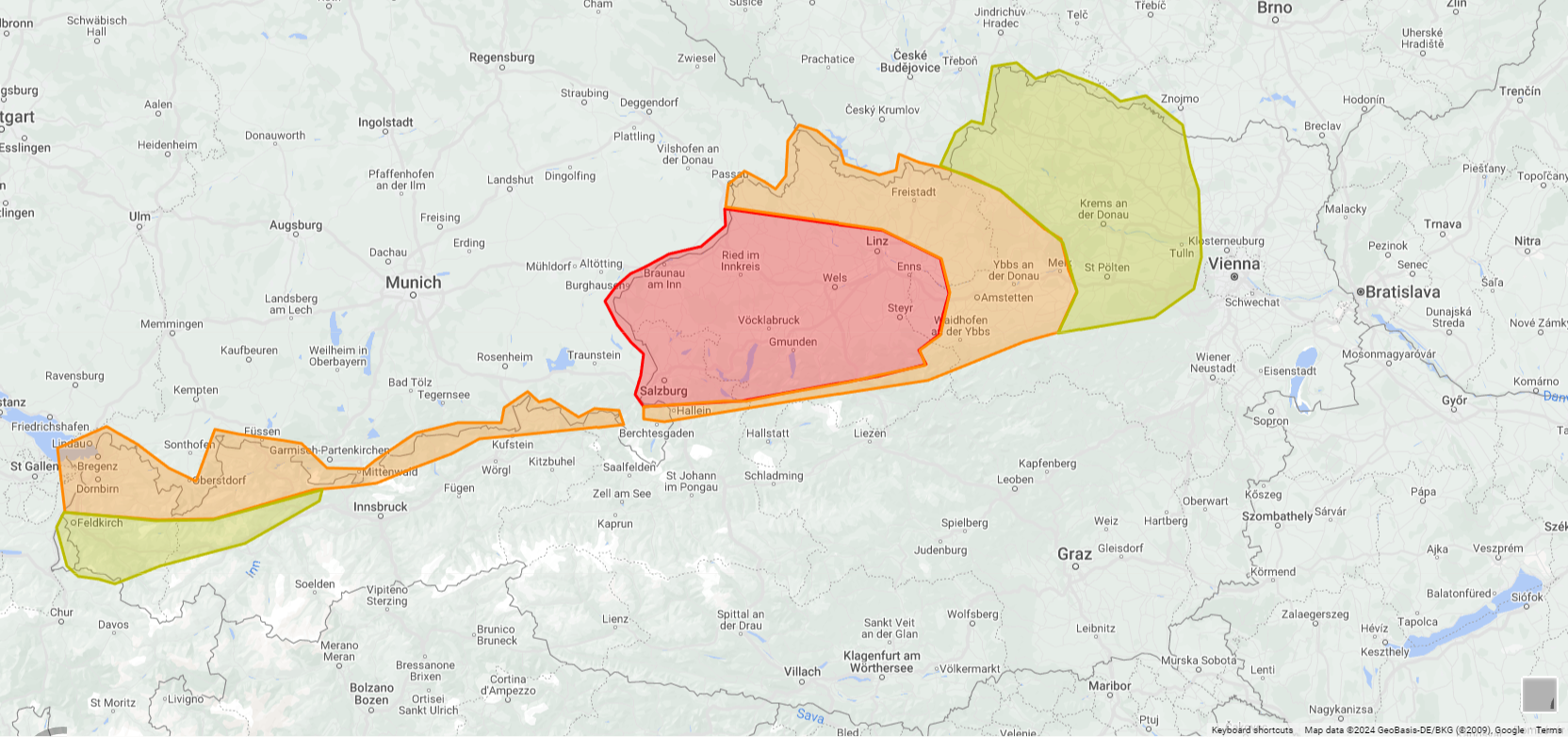
++ Forecast – Unwettergefahr an der Alpennordseite – 06.07.2024 09:15 ++
Mit Annäherung einer Störungszone steigt am Samstag das Unwetterrisiko an der Alpennordseite erheblich an. Am Nachmittag entwickeln sich über Bayern Gewitter, die sich rasch verstärken und ostwärts ziehen. Diese Zellen können auch das Grenzgebiet zwischen Tirol und Deutschland streifen. Am Abend, wahrscheinlich zwischen 18 und 19 Uhr, erreichen die Gewitter das nördliche Salzburg und Oberösterreich. Dabei sorgt die Gewitterlinie in diesen Gebieten für schwere Sturmböen, lokal sind sogar Orkanböen möglich.Weiters ist auch Starkregen zu erwarten, besonders Richtung Bayern und am Alpenrand ist auch Hagel (bis 3 cm, lokal auch größer) möglich. Die Linie zieht weiter ostwärts, wobei das Risiko für Starkregen und Hagel in etwa ab der Grenze zwischen Ober- und Niederösterreich deutlich abnimmt. Die Böenfront zieht jedoch mit wenig bzw. ohne Niederschlag weiter ostwärts und kann bis in den Wiener Raum für Sturmböen sorgen.
Weitere Gewitter können am Nachmittag und Abend aus Westen auch nach Vorarlberg und die angrenzenden Gebiete Tirols ziehen. Hauptgefahr sind hier ebenso Sturmböen und Starkregen, vereinzelt ist auch Hagel möglich. Nach Mitternacht klingen die Gewitter überall ab, Schauer sind aber besonders in den westlichen Landesteilen weiterhin möglich.
Forecaster: Gerald Knapp (Dustdevil)
Gültig von: 06.07.2024, 14:00
bis: 07.07.2024, 01:00
Erstellt: 06.07.2024, 09:12
ESTOFEX
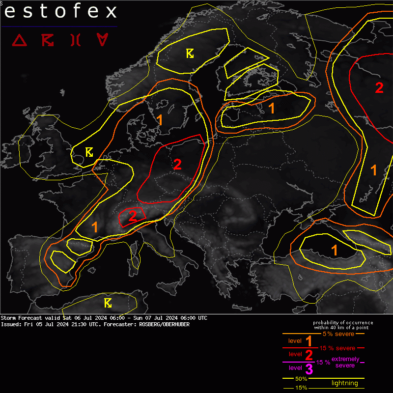
A level 2 was issued across Germany, Austria, Czech Republic and Poland mainly for severe wind gusts and large hail. A level 1 was issued surrounding the level 2 area for the same hazards but with lower probability.
... France, Germany, Austria, Czech Republic, Poland ...
In front of the incoming cold front widespread CI is expected over central Europe. Overnight convection over southern France is still ongoing in the morning hours. In an environment with low CAPE and moderate to high shear marginally large hail and isolated severe wind gusts are expected, if some storms manage to become surface based during the day over France and northern parts of Switzerland.
Over E Switzerland, S Germany and W Austria daytime heating leads to build-up of CAPE in the range of 1000 to 1500 J/kg. First storms are expected to initiate in the early afternoon hours along the northern edge of the alps. Within 15 to 20 m/s of DLS storms will quickly form to multicells and some supercells with risks of large hail and severe wind gusts. Right moving storms along the northern alpine rim could benefit from locally enhanced deep layer windshear due to incoming mountain valley winds. These storms would be able to produce very large hail.
Around the border from Germany to Czech Republic and NW Austria low level moisture tends to be lower. Boundary layer is well mixed, with spreads exceeding 15 K. Forecast soundings indicate some shape of inverted-V. Current thinking is that in such an environment incoming storms will create an increasingly strong cold pool. Thus, storm mode should mostly change to line segments and, while moving east, main risk is going to be severe wind gusts.
Some high resolution models indicate swaths of severe wind gusts in the range of 25 to 35 m/s from SE and E Germany all the way to northwestern Austria, western Czech Republic and western Poland. Taking into account the fact that high resolution models at times overestimate cold pool strength and severity of severe wind gusts.
However, confidence is high enough to issue a broad level 2.
While the wind gusts in the southern part of the level 2 are mostly thermodynamically driven, kinematics are slighly more favorable over eastern Germany and western Poland. 0-3 km bulk shear up to 15 m/s should compensate the lack of CAPE in this regions.


 Gewitter im grenzgebiet Bayern innviertel N-flachgau mit Sturm Starkregen und kleine Hagelkörner