
thx Herfried für deine Einschätzung
ja das in 200hpa hab ich auch schon gesehn, somit dürfts das einstrahlungshemmende zeugs zum großteil verblasen
Frontdurchgang von 17.7 auf 18.7?
-
Oliver B.
Das hört sich ja nicht so schlecht an für uns im mittleren Weinviertel oder bekommen wir hier evtl. auch etwas ab? Haben morgen Feuerwehrheurigen und das wäre kontra produktiv. 
-
Hannes
- Beiträge: 9616
- Registriert: Sonntag 19. April 2009, 21:30
- Wohnort: Kötschach-Mauthen 705m ü. Adria Bezirk Hermagor,Oberes Gailtal
merci Herfried
lg Hannes
------------------------------------------------------
Wetterstation: Vantage Pro 2 Aktiv, Hellmann 200cm² Webcam Mobotix
Standort [ x ] Kötschach-Mauthen 705m.ü.Adria / Bezirk Hermagor/Oberes Gailtal
Standort [ ] Graz Eggenberg
Standort [ ] Miesenbach bei Birkfeld
------------------------------------------------------
Wetterstation: Vantage Pro 2 Aktiv, Hellmann 200cm² Webcam Mobotix
Standort [ x ] Kötschach-Mauthen 705m.ü.Adria / Bezirk Hermagor/Oberes Gailtal
Standort [ ] Graz Eggenberg
Standort [ ] Miesenbach bei Birkfeld
Der Tag ist gekommen... 
Wirklich spannend das Ganze.
Heute werden wohl einige Organisatoren von diversen Veranstaltungen auf Nageln sitzen. Neben dem Life Ball ist geht heute auch die Bundesliga wieder los. Spielorte sind heute Kapfenberg, Wr. Neustadt und Ried. Ankick ist um 18:30. Um diese Zeit sind wohl im keinen dieser Orte Unwetter wirklich auszuschließen. Am ehesten noch Ried, weil die Front vielleicht dann schon durch ist.
Neudorf/Passail 810m (Bez. Weiz), Grazer Bergland
-
Chattiger
Ja, dieser Tag hat schon was prikelndes wenn ich das mal so sagen darf. Man wartet eigentlich nur drauf wann und wo es losgehen wird. Freue mich auf ein schönes Naturschauspiel, hoffentlich ohne Schäden usw.
-
Orestes
Tja wir sitzen auch auf Nadeln wegen heute Abend. Haben zwar ein Zelt aufgestellt aber naja.
Bei uns ist ja schon am Donnerstag der Bach übergegangen und ziemliche Schäden sind entstanden.
Kanaldeckel hochgedrückt, Autos davongeschwommen usw....
Bin also gespannt wie es heute für das Mittelburgenland aussieht.
Bei uns ist ja schon am Donnerstag der Bach übergegangen und ziemliche Schäden sind entstanden.
Kanaldeckel hochgedrückt, Autos davongeschwommen usw....
Bin also gespannt wie es heute für das Mittelburgenland aussieht.
-
ThomasWWN

- Beiträge: 6314
- Registriert: Sonntag 19. April 2009, 21:31
- Skype: thomaswwn
- Rufzeichen: OE3STF
- Wohnort: wochentags: 1030 Wien, Wochenende: 2603 Felixdorf
- Kontaktdaten:
Sollten wir diesen Thread nicht mal schließen?
Haben ja bereit die beiden gesplitteten Gewitterthreads!
Haben ja bereit die beiden gesplitteten Gewitterthreads!
ESWD | Weitere Funktion: ESWD User Support bei European Severe Storms Laboratory (ESSL)
ESSL > ESWD
Wetterstation 1030 Wien: https://www.ecowitt.net/home/index?id=79484
ESSL > ESWD
Wetterstation 1030 Wien: https://www.ecowitt.net/home/index?id=79484
-
Stoney

- Beiträge: 640
- Registriert: Mittwoch 22. April 2009, 08:44
- Skype: oe1ssu
- Rufzeichen: OE1SSU
- Wohnort: Wien
- Kontaktdaten:
Estofex Stufe 2
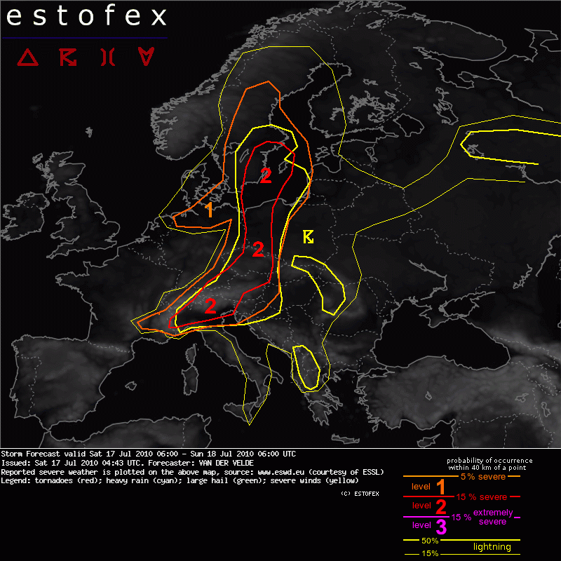
SYNOPSIS
A mid-level trough with its axis from W North Sea to S France at 12Z moves eastward. A cold front stretches from Sweden southward into W Poland towards N Switzerland, with a large body of moderate MLCAPE to its east and south. A secondary cold front behind it, especially in mid levels, will move over Germany. Lower MLCAPE and lower EL heights are forecast over N Germany, Netherlands, North Sea and Denmark during the afternoon. The quasi-geostrophic lifting associated with the trough is located in two maxima, one moving over Netherlands and eastern North Sea, the other over central France to the Alpine area. Weaker lift is present in a band between these regions. A shortwave within the trough moves over S Sweden. Sinking QG motions are initially forecast to be present over N Germany until 15Z.
Austria...
Up to 300 m²/s² SREH is found just west of the surface cold front in the border area of Germany and Poland. CAPE is highest east of the line, and slightly elevated to the west. However, it is likely that storms will be able to tap into the streamwise vorticity and start rotating. Hodographs indicate strong mid-level storm-relative winds. These factors and the abundant MLCAPE up to 2000 J/kg are favorable for strong cells with large/very large hail and severe wind gusts, which are enhanced by evaporational cooling indicated by delta theta-e > 20° and LCLs (east of the front) of 2500 m with steep low level lapse rates.
...northern Italy...
Large CAPE values >1600 J/kg already present in 00Z soundings, going over 2000 J/kg in GFS during the afternoon, and dry upper layers pose a threat of severe wind gusts. Large hail is also possible, once shear increases to marginally moderate values from the west. More importantly, and the reason for level 2, is the trough coming out of France passing the region during evening and night, setting off widespread storms with primary chance of severe wind gusts. Large hail and excessive precipitation can also occur.
lg Stefan,
Standort Wien 23 - Wetter: http://www.qth.at/oe1ssu/
Standort Niederösterreich, Kaiserkogel - Wetter + Webcam: http://adl304.oevsv.at/opencms/Wetter/
Standort Wien 23 - Wetter: http://www.qth.at/oe1ssu/
Standort Niederösterreich, Kaiserkogel - Wetter + Webcam: http://adl304.oevsv.at/opencms/Wetter/
-
chris188

- Beiträge: 3342
- Registriert: Dienstag 24. März 2009, 21:54
- Skype: esprit188
- Wohnort: Kirchschlag bei Linz (OÖ)
- Kontaktdaten:
ich schließe diesen thread - bitte im gewitterthread von heute weiterposten - danke!
@chris82
bitte um zurückhaltung - deine postings sind so nicht ok.
@chris82
bitte um zurückhaltung - deine postings sind so nicht ok.
lg, chris
http://www.wetter-muehlviertel.at
Kirchschlag bei Linz, Mühlviertel, OÖ (850m)
"Take the Time it takes so it takes less Time" - Pat Parelli
http://www.wetter-muehlviertel.at
Kirchschlag bei Linz, Mühlviertel, OÖ (850m)
"Take the Time it takes so it takes less Time" - Pat Parelli