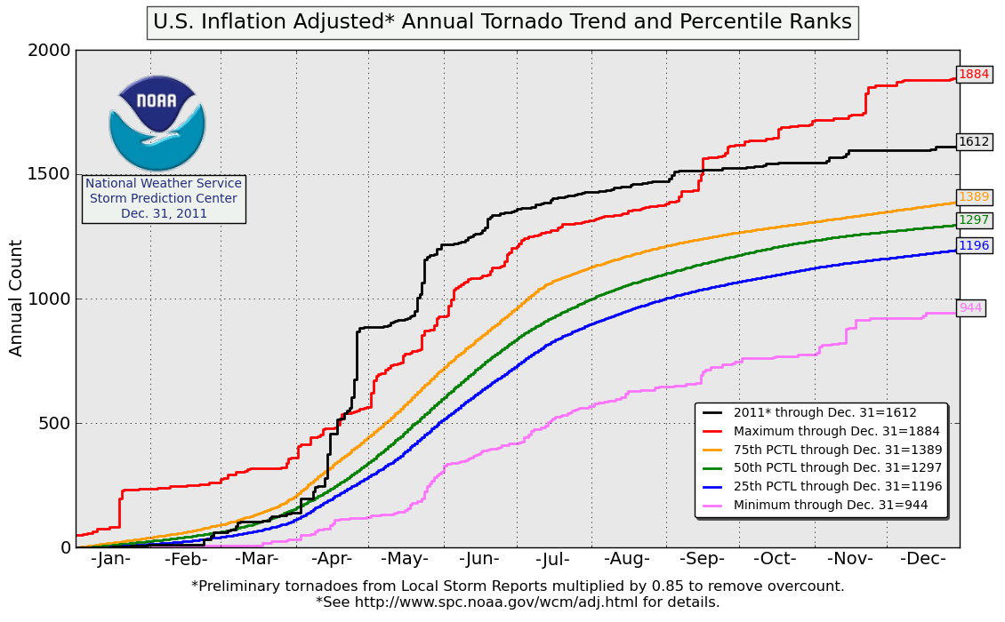
Tornados USA / N-Amerika 2011

Wetterinfos aus aller Welt
MarcoKTN
Beiträge: 6286
Registriert: Donnerstag 23. April 2009, 14:30
Skype: Marcoo
Wohnort: Amlach (620m ü Nn.) in Oberkärnten/Bezirk Spittal

Montag 18. April 2011, 21:49

ThomasWWN hat geschrieben:01:16 - "Diana (?) I love you"

Eindeutig falscher Standort.

dachte eher er spricht den Tornado an, nachdem er gottseidank knapp an ihnen vorbeizog

frag mich, warum die dort mit dem auto stehngeblieben sind. ich wär links über die wiese gebrettert
Amlach(620m ü.n.N)/Oberkärnten-Bezirk Spittal-Oberes Drautal
Benutzeravatar
ThomasWWN
Beiträge: 6314
Registriert: Sonntag 19. April 2009, 21:31
Skype: thomaswwn
Rufzeichen: OE3STF
Wohnort: wochentags: 1030 Wien, Wochenende: 2603 Felixdorf
Kontaktdaten:

Dienstag 19. April 2011, 08:53

Quelle: http://diepresse.com/home/panorama/welt ... t/index.do
Obama: Hilfe nach tödlicher Tornadoserie

19.04.2011 | 07:21 | (DiePresse.com)

267 Wirbelstürme fegten über 15 US-Staaten im Süden und Osten hinweg, 44 Menschen kamen ums Leben.

Nach einer der schwersten Tornadoserien der US-Geschichte mit nach jüngsten Angaben 44 Toten hat Präsident Barack Obama die Hilfe der Regierung beim Wiederaufbau der verwüsteten Regionen angeboten. Die Regierung sei bereit, dort zu helfen wo dies benötigt werde, sagte Obamas Sprecher Jay Carney am Montag (Ortszeit). Obama selbst sagte in einem Interview mit einem Fernsehsender des besonders betroffenen US-Staates North Carolina, die Zahl der Todesopfer breche ihm das Herz. Er und seine Frau Michelle sprächen allen betroffenen Familien ihr Beileid aus. "Wir werden alles irgend Mögliche tun, um beim Wiederaufbau zu helfen", sagte Obama dem Sender WRAL.

Von Donnerstag an war ein schwerer Sturm über den Süden der USA hinweggezogen. 267 Wirbelstürme fegten der Internetseite AccuWeather.com zufolge von Donnerstag bis Samstag über 15 US-Staaten im Süden und Osten der USA hinweg, rissen Bäume und Strommasten um, wirbelten Teile von Dächern durch die Luft und verwüsteten ganze Stadtteile. 44 Menschen kamen ums Leben, die meisten von ihnen im Südosten des Landes. Die Behörden hatten zunächst von 45 Toten gesprochen, ihre Zahlen dann aber korrigiert.

(APA)
ESWD | Weitere Funktion: ESWD User Support bei European Severe Storms Laboratory (ESSL)
ESSL > ESWD
Wetterstation 1030 Wien: https://www.ecowitt.net/home/index?id=79484
Benutzeravatar
Matthias
Beiträge: 6569
Registriert: Sonntag 19. April 2009, 19:43

Dienstag 19. April 2011, 09:21

SEHR gute Zusammenfassung am WeatherChannel!

Dauer: bisl mehr als 20 Minuten!

Link: http://www.weather.com/outlook/videos/f ... tion-20368" onclick="window.open(this.href);return false;

Beeindruckend... *schock*

Bild
lg,
Matthias

8072 Fernitz-Mellach, Graz-Umgebung

Wetterstation Fernitz: http://www.awekas.at/de/instrument.php?id=14717
MarcoKTN
Beiträge: 6286
Registriert: Donnerstag 23. April 2009, 14:30
Skype: Marcoo
Wohnort: Amlach (620m ü Nn.) in Oberkärnten/Bezirk Spittal

Mittwoch 20. April 2011, 08:48

feine squall derzeit in den usa

http://radar.weather.gov/Conus/full.php" onclick="window.open(this.href);return false;

wohl um die 1500km lang

die tornado reports halten sich in grenzen, dafür hagelts anständig (einige Tennisball-Orangen Meldungen) und gusts bis über 150km/h wurden gemessen
Amlach(620m ü.n.N)/Oberkärnten-Bezirk Spittal-Oberes Drautal
Benutzeravatar
ThomasWWN
Beiträge: 6314
Registriert: Sonntag 19. April 2009, 21:31
Skype: thomaswwn
Rufzeichen: OE3STF
Wohnort: wochentags: 1030 Wien, Wochenende: 2603 Felixdorf
Kontaktdaten:

Mittwoch 20. April 2011, 09:36

19. April, Aufnahmen von TornadoVideos.net

Hier erscheint normalerweise ein Video von YouTube. Bitte wende dich an einen Administrator.

Up-close video of tornadoes in northeast MO into IL

Written by Reed Timmer
Tuesday, 19 April 2011 21:42

Video of two tornadoes on April 19, 2011; the first near Bowling Green, MO and the second just east of Carlinville, IL. These supercells tracked eastward right along a sharp warm front orieted W-E from a surface low in northern MO yielding enhanced low-level wind shear.
Hier erscheint normalerweise ein Video von YouTube. Bitte wende dich an einen Administrator.
ESWD | Weitere Funktion: ESWD User Support bei European Severe Storms Laboratory (ESSL)
ESSL > ESWD
Wetterstation 1030 Wien: https://www.ecowitt.net/home/index?id=79484
Benutzeravatar
ThomasWWN
Beiträge: 6314
Registriert: Sonntag 19. April 2009, 21:31
Skype: thomaswwn
Rufzeichen: OE3STF
Wohnort: wochentags: 1030 Wien, Wochenende: 2603 Felixdorf
Kontaktdaten:

Mittwoch 20. April 2011, 14:41

Bilanz der NOOA für Dienstag, 19.04.2011

Bild
The NWS Storm Prediction Center in Norman, Okla., received more than 700 reports of severe weather on Tuesday across a large area stretching from the lower Great Lakes and Ohio Valley southwestward into the Mississippi Valley and southern Plains. Numerous tornadoes were reported in Missouri, Illinois, Ohio, and Arkansas. SPC is forecasting a slight risk of severe thunderstorms today from eastern Texas eastward to the western Carolinas and across the Mid-Atlantic.
ESWD | Weitere Funktion: ESWD User Support bei European Severe Storms Laboratory (ESSL)
ESSL > ESWD
Wetterstation 1030 Wien: https://www.ecowitt.net/home/index?id=79484
Benutzeravatar
Mulvane
Beiträge: 1484
Registriert: Sonntag 16. Mai 2010, 16:15
Wohnort: Feldkirchen/Ktn. (580m)

Mittwoch 20. April 2011, 18:09

Danke euch für das suchen und reinstellen dieser immer wieder extrem beeindruckenden Videos. *top* *super*
Schöne Grüße aus dem Süden.
Hele *wink* Feldkirchen/Ktn. ca.580m
Benutzeravatar
ThomasWWN
Beiträge: 6314
Registriert: Sonntag 19. April 2009, 21:31
Skype: thomaswwn
Rufzeichen: OE3STF
Wohnort: wochentags: 1030 Wien, Wochenende: 2603 Felixdorf
Kontaktdaten:

Donnerstag 21. April 2011, 19:50

Ist bereits ein paar Tage her, aber einige Szenen sind echt sehenswert!


Tornado Breakout in North Carolina - April 16, 2011
Hier erscheint normalerweise ein Video von YouTube. Bitte wende dich an einen Administrator.
ESWD | Weitere Funktion: ESWD User Support bei European Severe Storms Laboratory (ESSL)
ESSL > ESWD
Wetterstation 1030 Wien: https://www.ecowitt.net/home/index?id=79484
Rusty01
Beiträge: 177
Registriert: Donnerstag 2. Juli 2009, 10:46
Wohnort: Hollabrunn/Peigarten

Samstag 23. April 2011, 06:32

Morgen ........

Der nächste Tornado ( St. Louis Missouri )

http://www.kplr11.com/news/ktvi-lambert ... 2609.story" onclick="window.open(this.href);return false;
Hollabrunn Zentrum 236 m ü. A. 48° 34′ N, 16° 5′ O
Benutzeravatar
ThomasWWN
Beiträge: 6314
Registriert: Sonntag 19. April 2009, 21:31
Skype: thomaswwn
Rufzeichen: OE3STF
Wohnort: wochentags: 1030 Wien, Wochenende: 2603 Felixdorf
Kontaktdaten:

Samstag 23. April 2011, 08:46

Hier ein paar zusammengetragene Materialien zum Tornado in St. Louis, Missouri, USA(http://maps.google.at/maps?f=q&source=s ... aaten&z=14
The Weather Channel and weather.com
Reports from KMOX Radio of a plane that may have been lifted by a tornado at St. Louis Lambert with people aboard. The same report mentioned crews were having difficulty getting to the plane as it was surrounded by debris. One observer tweeted he saw a plane "pushed 20 yards from its gate" by the winds. Here's another pic of the mess at Lambert Airport, which is now closed.

Bild
Quelle: http://a7.sphotos.ak.fbcdn.net/hphotos- ... 5870_n.jpg

The Weather Channel and weather.com
An apparent tornado has blown out windows and taken a roof off, and flipped cars at St. Louis Lambert Int'l Airport. Parts of I-270 are shut down in north side of city due to downed power lines. Follow the latest developments on this, including pictures and damage reports here: http://twitter.com/#!/TWCBreaking

Bild
Quelle: http://a8.sphotos.ak.fbcdn.net/hphotos- ... 9867_n.jpg
(Quelle: Facebook-Auftritt von The Weather Channel and weather.com)

Die nächsten Stürme stehen bereits bevor - hier eine (leider schon zwei Tage alte...) Prognose:
An Insane Outbreak of Severe Weather Next Week
Apr 21, 2011; 12:13 PM ET

Discussion

The weather has just gone insane with the pattern that will evolve next week across the eastern half of the country. While I enjoy the meteorology of the events that will unfold, knowing that there is potential for loss of life in the pattern coming is not comforting to me. When I said that I expect up to 300 tornadoes in the next two weeks, I was not kidding. Given the pattern next week, I can see 100-200 tornadoes over a four-day period starting Monday, as I have outlined on the map below.

There is no doubt that the ingredients for the severe weather outbreak will be in place next week. We will have a strong jet stream, plenty of heat and humidity, and at least two potent storms. People living in the area that I am showing on the map should be aware of the extreme weather coming next week.
Bild

Quelle: http://www.accuweather.com/blogs/meteom ... t-week.asp
ESWD | Weitere Funktion: ESWD User Support bei European Severe Storms Laboratory (ESSL)
ESSL > ESWD
Wetterstation 1030 Wien: https://www.ecowitt.net/home/index?id=79484
Rusty01
Beiträge: 177
Registriert: Donnerstag 2. Juli 2009, 10:46
Wohnort: Hollabrunn/Peigarten

Samstag 23. April 2011, 09:09

@Thomas
Danke für die Zusammenfassung und den Bilder , war leider zu der zeit noch nicht 100% pc tauglich . :)
Hollabrunn Zentrum 236 m ü. A. 48° 34′ N, 16° 5′ O
Benutzeravatar
ThomasWWN
Beiträge: 6314
Registriert: Sonntag 19. April 2009, 21:31
Skype: thomaswwn
Rufzeichen: OE3STF
Wohnort: wochentags: 1030 Wien, Wochenende: 2603 Felixdorf
Kontaktdaten:

Samstag 23. April 2011, 09:35

Rusty01 hat geschrieben:@Thomas
Danke für die Zusammenfassung und den Bilder , war leider zu der zeit noch nicht 100% pc tauglich . :)
aber sicher doch ;)
ESWD | Weitere Funktion: ESWD User Support bei European Severe Storms Laboratory (ESSL)
ESSL > ESWD
Wetterstation 1030 Wien: https://www.ecowitt.net/home/index?id=79484
MarcoKTN
Beiträge: 6286
Registriert: Donnerstag 23. April 2009, 14:30
Skype: Marcoo
Wohnort: Amlach (620m ü Nn.) in Oberkärnten/Bezirk Spittal

Samstag 23. April 2011, 09:57

Bild


*ko*

ich hoffe die kommende Woche wird nicht allzu arg *huch*
Amlach(620m ü.n.N)/Oberkärnten-Bezirk Spittal-Oberes Drautal
Benutzeravatar
fifo1980
Beiträge: 200
Registriert: Dienstag 18. Mai 2010, 23:00
Wohnort: Sankt Koloman

Samstag 23. April 2011, 12:04

MarcoKTN hat geschrieben:Bild


*ko*

ich hoffe die kommende Woche wird nicht allzu arg *huch*
Hallo Marco,

könntest du für "Unwissende" kurz das Radisondenaustiegsdiagramm für das Beispiel grob erklären?
Was an in dem Fall so *ko* ist. Hab das noch nicht so ganz durchschaut.
Vielen Dank
5423 Sankt Koloman
Benutzeravatar
ThomasWWN
Beiträge: 6314
Registriert: Sonntag 19. April 2009, 21:31
Skype: thomaswwn
Rufzeichen: OE3STF
Wohnort: wochentags: 1030 Wien, Wochenende: 2603 Felixdorf
Kontaktdaten:

Samstag 23. April 2011, 12:06

Hier gibts noch ein wenig mehr:

Crews clean after tornado hits St. Louis airport

The Associated Press

Friday, April 22, 2011 | 7:46 p.m.

St. Louis' main airport was closed for business Saturday while crews cleaned up after an apparent tornado tore through a terminal, causing several injuries and sending people scurrying for shelter as plated glass shattered around them.

Friday evening's storm at Lambert-St. Louis International Airport ripped away a large section of the main terminal's roof, forcing the airport to close indefinitely and diverting incoming flights to other cities.

Elsewhere around St. Louis, residents in suburbs were waking to damaged homes, fallen trees and downed power lines _ the remains of a fierce line of storms that moved through central and eastern Missouri.

"We have all hands on deck here," Mayor Francis Slay said at the airport. "This is something we're putting a lot of attention to."

But amid all the damage, there was relief that things could have been worse. Only four people with minor injuries were taken to the hospital from Lambert, while an unspecified number of others were treated at the scene for cuts blamed on flying glass.

"We're fortunate we didn't have larger (numbers) of injuries," said airport director Rhonda Hamm-Niebruegge.

The airport's main terminal sustained the most damage. Hamm-Niebruegge said roughly half of that structure's windows were blown out, sending glass and rain into that building. Elsewhere on the property, trees were toppled and power lines downed, further limiting access to the airport even hours after the storm left its destruction.

Passengers from at least two planes were stranded briefly on the Lambert tarmac because of debris but were later taken away by buses. An Air National Guard facility at the airport was reportedly damaged.

Unconfirmed tornadoes were reported in several counties in the St. Louis area, and at one point utility company Ameren Missouri reported more than 47,000 power outages, with another 7,000 reported in Illinois.

In the suburbs of Maryland Heights and New Melle, the storms damaged several dozen homes but there were no immediate reports of major injuries. Some playground equipment in New Melle was left in a twisted heap by the storm that also tore up roofs and ripped off siding.

Brandon Blecher, 16, said he was home watching the storm out his window in Maryland Heights when he spotted the tornado coming toward his house. A gust of wind knocked out his window.

"The giant wooden swing set in my neighbor's yard came into my yard and a shed landed on my deck," he said. "The tornado was right on top of us."

Maryland Heights police were dealing with reports of gas leaks and downed trees that were blocking roadways.

The city's community center was opened as a shelter Friday night for residents affected by the storm.

"We have electricity, and everything's fine," Vaughn said. "We have heat and air. We'll be here as long as we need to be."

Damage, possibly from a tornado, was also reported at several towns near the airport _ Bridgeton, St. Ann, Ferguson and Florissant. Interstate 270 in that area was closed. Trees and power lines were down. A tractor-trailer was sitting on its end.

In downtown St. Louis, Busch Stadium officials hurriedly moved Cardinals fans to a safe area as tornado sirens blared. The game with the Cincinnati Reds was delayed for hours but later resumed.

At Lambert, installation and roofing tile was strewn about the inside and outside of one terminal. Large, plate-glass windows were blown out. A shuttle was teetering precariously from the top level of a parking garage.

Dianna Merrill, 43, a mail carrier from St. Louis, was at Lambert waiting to fly to New York with a friend for vacation. She said her flight had been delayed by weather and she was looking out a window hoping her plane would pull up. But the window suddenly exploded.

"Glass was blowing everywhere. The ceiling was falling. The glass was hitting us in the face. Hail and rain were coming in. The wind was blowing debris all over the place," she said. "It was like being in a horror movie. Grown men were crying. It was horrible."

Merrill said she felt lucky to be alive and that airport workers quickly moved people to stairwells and bathrooms to get them out of harm's way.

St. Louis County Police Chief Tim Fitch, who was at the airport when the storm was closing in, said he saw gawkers watching the weather outside as the tornado sirens blared. Moments later, they hastily scrambled inside the building and sought shelter in a restroom.

"About the time we came into the building, the doors blew off," he said. "Literally 10 seconds later, it was over. It's amazing to me more people weren't hurt."

Gov. Jay Nixon announced late Friday he had declared a state of emergency, allowing state agencies to assist local jurisdictions with their emergency responses to the storm's aftermath, including the destruction at Lambert.

"The state of Missouri is ready to assist at every stage of this emergency to keep Missouri families safe and help communities recover," Nixon said.

Quelle: http://www.lasvegassun.com/news/2011/ap ... ri-storms/
St. Louis Airport Closed After Reported Tornado Rips Through Facility

Published April 23, 2011

April 22: Storm damage is seen next to a parking garage outside terminal one at St. Louis International Airport in St. Louis. Several people at Lambert Airport in St. Louis were injured Friday after an apparent tornado touched down, spewing debris over the airfield, bursting glass in the concourse and damaging cars atop a parking garage. (AP)

An apparent tornado ripped through St. Louis' International Airport Friday, injuring several people and forcing the airport to be closed indefinitely.

There was extensive damage to the airport's busiest terminal, where 40 to 50 percent of glass was blown in, according to Lambert-St. Louis International Airport Spokesman Jeff Lea.

Mayor Francis Slay said Lambert would be shut down "indefinitely," impacting 256 daily departures and arrivals from the facility.

Gov. Jay Nixon announced late Friday he had declared a state of emergency, allowing state agencies to assist local jurisdictions with their emergency responses to the storm's aftermath, including the destruction at Lambert.

"The state of Missouri is ready to assist at every stage of this emergency to keep Missouri families safe and help communities recover," Nixon said.

Friday evening's storm at Lambert-St. Louis International Airport ripped away a large section of the main terminal's roof, forcing the airport to close indefinitely and diverting incoming flights to other cities.

"We have all hands on deck here," Mayor Francis Slay said at the airport. "This is something we're putting a lot of attention to."

But amid all the damage, there was relief that things could have been worse. Only four people with minor injuries were taken to the hospital from Lambert, while an unspecified number of others were treated at the scene for cuts blamed on flying glass.

"We're fortunate we didn't have larger (numbers) of injuries," said airport director Rhonda Hamm-Niebruegge.

The airport's main terminal sustained the most damage. Hamm-Niebruegge said roughly half of that structure's windows were blown out, sending glass and rain into that building. Elsewhere on the property, trees were toppled and power lines downed, further limiting access to the airport even hours after the storm left its destruction.

Passengers from at least two planes were stranded briefly on the Lambert tarmac because of debris but were later taken away by buses. An Air National Guard facility at the airport was reportedly damaged.

Installation and roofing tile was strewn about the inside and outside of one terminal. Large, plate-glass windows were blown out. A shuttle was teetering precariously from the top level of a parking garage.

Dianna Merrill, 43, a mail carrier from St. Louis, was at Lambert waiting to fly to New York with a friend for vacation. She said her flight had been delayed by weather and she was looking out a window hoping her plane would pull up. But the window suddenly exploded.

"Glass was blowing everywhere. The ceiling was falling. The glass was hitting us in the face. Hail and rain were coming in. The wind was blowing debris all over the place," she said. "It was like being in a horror movie. Grown men were crying. It was horrible."

Merrill said she felt lucky to be alive and that airport workers quickly moved people to stairwells and bathrooms to get them out of harm's way.

St. Louis County Police Chief Tim Fitch, who was at the airport when the storm was closing in, said he saw gawkers watching the weather outside as the tornado sirens blared. Moments later, they hastily scrambled inside the building and sought shelter in a restroom.

"About the time we came into the building, the doors blew off," he said. "Literally 10 seconds later, it was over. It's amazing to me more people weren't hurt."

Elsewhere around St. Louis, residents in suburbs were waking to damaged homes, fallen trees and downed power lines -- the remains of a fierce line of storms that moved through central and eastern Missouri.

Unconfirmed tornadoes were reported in several counties in the St. Louis area, and at one point utility company Ameren Missouri reported more than 47,000 power outages, with another 7,000 reported in Illinois.

In the suburbs of Maryland Heights and New Melle, the storms damaged several dozen homes but there were no immediate reports of major injuries. Some playground equipment in New Melle was left in a twisted heap by the storm that also tore up roofs and ripped off siding.

Brandon Blecher, 16, said he was home watching the storm out his window in Maryland Heights when he spotted the tornado coming toward his house. A gust of wind knocked out his window.

"The giant wooden swing set in my neighbor's yard came into my yard and a shed landed on my deck," he said. "The tornado was right on top of us."

Maryland Heights police were dealing with reports of gas leaks and downed trees that were blocking roadways.

The city's community center was opened as a shelter Friday night for residents affected by the storm.

"We have electricity, and everything's fine," Vaughn said. "We have heat and air. We'll be here as long as we need to be."

Damage, possibly from a tornado, was also reported at several towns near the airport -- Bridgeton, St. Ann, Ferguson and Florissant. Interstate 270 in that area was closed. Trees and power lines were down. A tractor-trailer was sitting on its end.

In downtown St. Louis, Busch Stadium officials hurriedly moved Cardinals fans to a safe area as tornado sirens blared. The game with the Cincinnati Reds was delayed for hours but later resumed.

The Associated Press contributed to this report.

Quelle: http://www.foxnews.com/us/2011/04/22/in ... s-airport/

Hier erscheint normalerweise ein Video von YouTube. Bitte wende dich an einen Administrator.


Hier erscheint normalerweise ein Video von YouTube. Bitte wende dich an einen Administrator.


01.25 ist äußerst spektakülär:

Hier erscheint normalerweise ein Video von YouTube. Bitte wende dich an einen Administrator.


ein weiteres Video:

http://www.kmov.com/news/local/Storms-c ... 23519.html
ESWD | Weitere Funktion: ESWD User Support bei European Severe Storms Laboratory (ESSL)
ESSL > ESWD
Wetterstation 1030 Wien: https://www.ecowitt.net/home/index?id=79484
Benutzeravatar
Matthias
Beiträge: 6569
Registriert: Sonntag 19. April 2009, 19:43

Sonntag 24. April 2011, 18:55

Erster EF4-Tornado der Saison in den USA.
Große materielle Schäden...

LINK:
http://www.stltoday.com/news/local/metr ... 2eb68.html" onclick="window.open(this.href);return false;
lg,
Matthias

8072 Fernitz-Mellach, Graz-Umgebung

Wetterstation Fernitz: http://www.awekas.at/de/instrument.php?id=14717
Benutzeravatar
Mulvane
Beiträge: 1484
Registriert: Sonntag 16. Mai 2010, 16:15
Wohnort: Feldkirchen/Ktn. (580m)

Montag 25. April 2011, 03:12

Und erneut geht die Post ab. *huch* Mehrere Tornadomeldungen gibts unter anderem aus Texas,und ein weiterer wurde in Kentucky gesichtet.
Schwere Gewitter,mit zum Teil großen bis sehr großen Hagel,werden aus Texas,Oklahoma,Arkansas,und Kentucky gemeldet.
Aus Abilene(Texas) z.B. gibt es Berichte von Hagelgeschoße,die eine Größe von bis zu 11,4cm erreicht haben sollen. *schock* *schock* *schock*
Schöne Grüße aus dem Süden.
Hele *wink* Feldkirchen/Ktn. ca.580m
Benutzeravatar
Matthias
Beiträge: 6569
Registriert: Sonntag 19. April 2009, 19:43

Montag 25. April 2011, 09:28

Video der Überwachungs-Kameras am Flughafen St. Louis:
SEHR spektakulär - man sieht, wie lose Teile, Papier richtig AUFGESAUGT wird!!! *schock* *top*
http://www.weather.com/outlook/videos/s ... 0424#20421" onclick="window.open(this.href);return false;

...im Anschluss daran kann man sich auch andere Videos auf Weather.com anschuen = EMPFEHLENSWERT!
Mulvane hat geschrieben: Aus Abilene(Texas) z.B. gibt es Berichte von Hagelgeschoße,die eine Größe von bis zu 11,4cm erreicht haben sollen. *schock* *schock* *schock*
Abilane is ein echter Hot Spot in Texas.
wenn da mal was im Anrollen ist --> DAS is eine gute Target Area, wenn man chasen geht und auf eine Auslöse wartet.

Auszug aus den Storm Reports:
2145 UTC 4.50 INCH 1 S ABILENE TAYLOR TX 3243 9973 (SJT)
4,50 Inch = 11,52cm ;)


HEUTE wieder Outbreak-Tag!

THE GREATEST SEVERE THREAT IS EXPECTED TO MATERIALIZE BETWEEN 21-00Z
OVER NERN TX...SPREADING NEWD ACROSS MUCH OF AR AND FAR SRN MO AS
THE UPPER JET DEVELOPS AND LIFT NEWD. WITH AMPLE MOISTURE AND A 50
KT LOW LEVEL JET...THERE APPEARS TO BE A SIGNIFICANT THREAT OF
TORNADOES...A FEW STRONG...AND DAMAGING WINDS. THE EXACT NRN EXTENT
OF THE STRONG TORNADO THREAT WILL DEPEND ON WHERE THE WARM FRONT/OLD
CONVECTIVE BOUNDARIES ARE.


TORNADOS:

http://www.spc.noaa.gov/products/outloo ... rn_prt.gif" onclick="window.open(this.href);return false;

GROSSHAGEL:

http://www.spc.noaa.gov/products/outloo ... il_prt.gif" onclick="window.open(this.href);return false;
lg,
Matthias

8072 Fernitz-Mellach, Graz-Umgebung

Wetterstation Fernitz: http://www.awekas.at/de/instrument.php?id=14717
Benutzeravatar
fifo1980
Beiträge: 200
Registriert: Dienstag 18. Mai 2010, 23:00
Wohnort: Sankt Koloman

Montag 25. April 2011, 09:36

es sind schon einige videos aus abilane online
zb.
http://www.youtube.com/watch?v=03gWyFOF ... re=related" onclick="window.open(this.href);return false; *schock*
5423 Sankt Koloman
Benutzeravatar
Matthias
Beiträge: 6569
Registriert: Sonntag 19. April 2009, 19:43

Montag 25. April 2011, 09:42

fifo1980 hat geschrieben:es sind schon einige videos aus abilane online
zb.
Hier erscheint normalerweise ein Video von YouTube. Bitte wende dich an einen Administrator.
*schock*
Ja bist du deppert!!!!!!!!!!!!!!!!!!!!!!!!!!!!!!!!!!!!!!! *schock* *schock* *schock*

--> ein Photo davon gibts aber auch :D

Quelle: http://www.weather.com" onclick="window.open(this.href);return false;

LINK anklicken - is für das Forum zu GROSS ;)
http://media.kickstatic.com/kickapps/im ... 868_ap.jpg" onclick="window.open(this.href);return false;
lg,
Matthias

8072 Fernitz-Mellach, Graz-Umgebung

Wetterstation Fernitz: http://www.awekas.at/de/instrument.php?id=14717
Benutzeravatar
Matthias
Beiträge: 6569
Registriert: Sonntag 19. April 2009, 19:43

Dienstag 26. April 2011, 14:22

Ein fettes Ding gabs gestern in Arkansas...

Vermutet wird ein EF4, mal schauen, was da noch herausgefunden wird!

Quelle:
http://okcstormwatcher.wordpress.com/20 ... r-tornado/" onclick="window.open(this.href);return false;
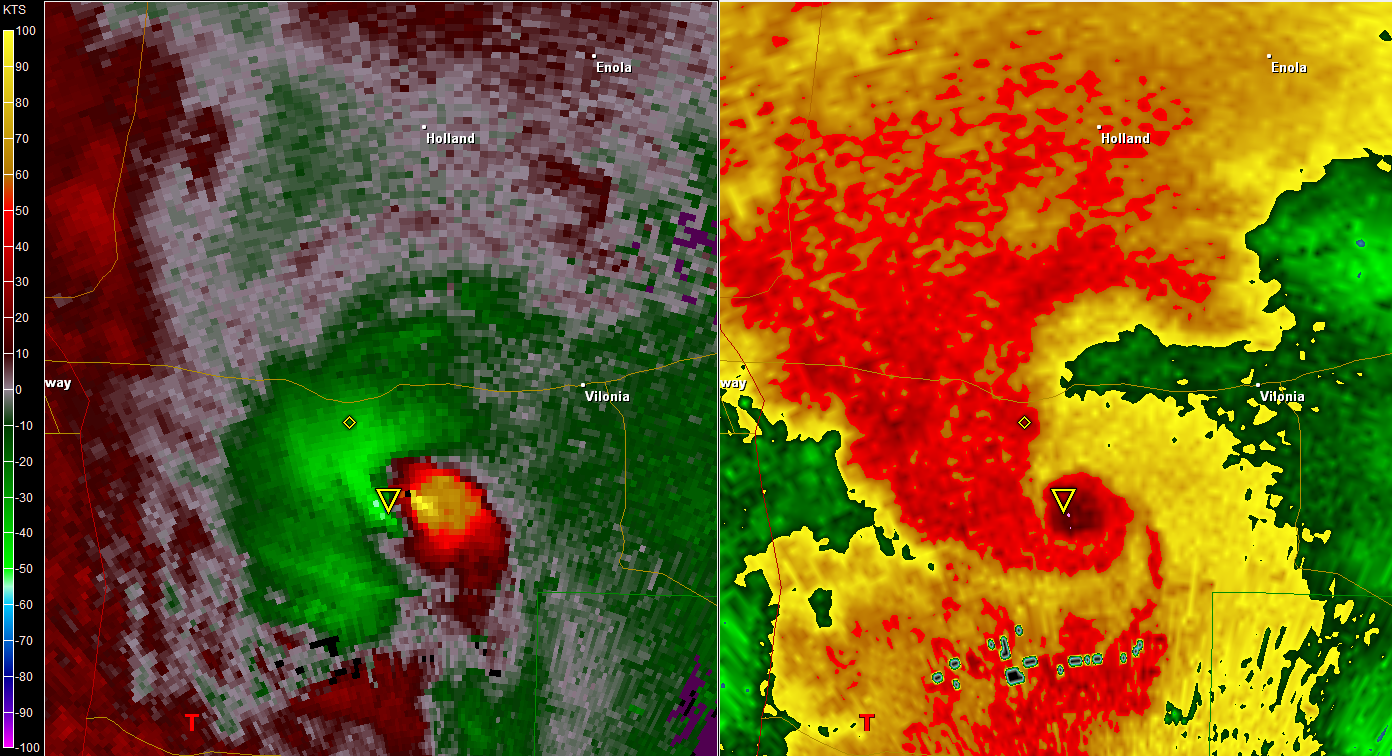
A major tornado has torn through the town of Vilonia, Arkansas this evening between 7 and 730 pm this evening. Pavement was reported scoured off the road just in Vilonia. Storm spotters said the tornado that moved into Vilonia was a half-mile wide and also had one of the strongest couplets ever to appear on radar.

Also, trained amatuer radio storm spotters confirmed cars were blown off the road on parts of I-40 and near the town of Vilonia. Unconfirmed reports from the Vilonia PD reports “town is gone,” pavement has been scoured outside of town. Also, police reporting 1/2 mile wide destruction in Vilonia, AR. To hear that there was very few injuries so far with this tornado, that’s nothing short of a miracle. Advance warning of up to 20 minutes aided in this. Unfortunately, in that, there has been 1 fatality in Vilonia as a result of this tornado.

Faulkner County spokesman Stephan Hawks says one person died in the central Arkansas town of Vilonia, where a path of damage stretches three miles wide and 15 miles long. It wasn’t immediately clear how the person died.

“Debris signature showing up on radar with strong rotation crossing I-40 NW of Little Rock near Mayflower”-The Weather Channel. The Weather Channel report a debris ball signature something similar to the debris ball on the St Louis tornado last Friday night. This debris ball was on the radar out of the north sides of Little Rock for more than 30 minutes. Below is the radar image of that debris ball.

Here is what some of the storm chasers on Twitter has been saying about this tornado.

“I bet Vilonia gets an EF5 rating. Very bad situation up there.”-Reed Timmer, star of the show “Storm Chasers” and Tornadovideos.net extreme storm chaser.

“Bad news: Vilonia is confirmed gone. Good news: Few injuries reported due to ample warning. Things can be replaced, lives can’t”-Bart Comstock, extreme storm chaser.

The National Weather Service (NWS) is reporting storm debris in Vilonia (Faulkner County). Also, Highway 64 inside the city limits is reported closed. That’s also where an 18-wheeler was blown over. Tornado warnings were posted in the area when the storm moved through around seven o’clock. When it moved over Maumelle, golf ball-sized hail was reported. On Interstate 40 near Morrilton, Arkansas, vehicles have been blown off the road, according to Arkansas State Police.

Around the same time, a tornado was reportedly spotted near Crystal Hill Road moving into North Little Rock, and there were reports that NWS personnel in NLR had to abandon their station and take shelter. The NWS also reports one person was hurt when windows were blown out of a car on Interstate 40 at Morgan just after 7:15 tonight.

The Storm Prediction Center had predicted significant severe weather over much of Arkansas for Monday, and storms quickly grew violent in the heat of the day. Forecasters say Tuesday could bring another bout of bad weather and that storms could delay assessment of Monday’s damage. Here are more storm reports from the area. This blog will be updated with the latest information as it becomes available.

4/25/2011 0750 PM: A possible tornado was spotted near the airport in North Little Rock, moving toward the Little Rock Air Force Base. Another tornado was reported in White County. A church was reportedly damaged on Interstate 40 near Maumelle. Near Mayflower, Highways 365 south and 89 south are blocked by storm debris. A police officer said cars had blown off the road and trees were knocked down between Morgan and Mayflower. Structural damage was reported in Vilonia from a possible tornado.

4/25/2011 0731 PM: Downtown Little Rock was in the path of another dangerous storm front as damage and injuries were reported Monday in central Arkansas. In Faulkner County, a possible tornado was reported near Vilonia. A tornado warning was also in effect until 7:45 p.m. for Faulkner, Lonoke, Pulaski and Saline counties

4/25/2011 0730 PM: 6 miles N of Vilonia, Faulkner County.Thunderstorm wind damage, reported by law enforcement. An 18 Wheeler was blown over.

4/25/2011 0725 PM: Vilonia, Faulkner County. Tornado, reported by amateur radio. Trees and power lines were down… blocking Highway 64. Also reports of most of the town, including downtown Vilonia has been damaged/destroyed.

4/25/2011 0714 PM: 3 miles E of Mayflower, Faulkner County.Tornado, reported by law enforcement. Tornado was reported on Highway 89.

4/25/2011 0711 PM: 1 miles N of Wooster, Faulkner County. Thunderstorm wind damage, reported by amateur radio. Trees and power lines were blown down.

4/25/2011 0710 PM: 1 miles E of Mayflower, Faulkner County. Thunderstorm wind damage, reported by trained spotter. Major damage has been reported along Highway 89. Power lines were down… and a vehicle was blown off the Road. There is at least a half mile wide swath of downed trees.

4/25/2011 0708 PM: Wooster, Faulkner County. Thunderstorm wind damage, reported by other federal.
Many trees were blown down… with some roof damage. A car was blown off the Road. Time is approximated based on radar.

Also, damage reported at the Little Rock AFB, roof damage to houses and cars tossed around. A church, other structures damaged near Morgan, Maumelle, Ark. areas. Injuries also reported. This is also from the tornado previously mentioned.

Note the wording of this bulletin issued prior to when the tornado hit Vilonia. You could tell by the wording the Little Rock NWS office, this was a dire, life-threatening situation, seeing that one fatality has been reported already.
Bild
lg,
Matthias

8072 Fernitz-Mellach, Graz-Umgebung

Wetterstation Fernitz: http://www.awekas.at/de/instrument.php?id=14717
MarcoKTN
Beiträge: 6286
Registriert: Donnerstag 23. April 2009, 14:30
Skype: Marcoo
Wohnort: Amlach (620m ü Nn.) in Oberkärnten/Bezirk Spittal

Dienstag 26. April 2011, 16:27

heute gibts ein high risk, ähnliche gebiete als gestern

derzeit gute einstrahlung dort
Amlach(620m ü.n.N)/Oberkärnten-Bezirk Spittal-Oberes Drautal
MarcoKTN
Beiträge: 6286
Registriert: Donnerstag 23. April 2009, 14:30
Skype: Marcoo
Wohnort: Amlach (620m ü Nn.) in Oberkärnten/Bezirk Spittal

Mittwoch 27. April 2011, 00:04

derzeit 8 Zellen mit Tornado warning

hook-echo auch an manchen zu erkennen
Amlach(620m ü.n.N)/Oberkärnten-Bezirk Spittal-Oberes Drautal
Benutzeravatar
ThomasWWN
Beiträge: 6314
Registriert: Sonntag 19. April 2009, 21:31
Skype: thomaswwn
Rufzeichen: OE3STF
Wohnort: wochentags: 1030 Wien, Wochenende: 2603 Felixdorf
Kontaktdaten:

Mittwoch 27. April 2011, 07:50

Und hier sind sie - die ersten Meldungen in den österreichischen Medien:
USA
- Mindestens zehn Tote nach Unwetter im Mittleren Westen

27. April 2011, 06:10

Notstand in Arkansas, Missouri, Illinois, Indiana und Kentucky ausgerufen

Washington - Durch schwere Unwetter im Mittleren Westen der USA sind mindestens zehn Menschen ums Leben gekommen. Im US-Staat Arkansas wurden vier Menschen getötet, als am Montagabend ein Tornado schwere Schäden anrichtete, wie eine Sprecherin des Katastrophenschutzministeriums am Dienstag sagte. In fünf Bundesstaaten wurde der Notstand ausgerufen.

Nach sintflutartigen Regenfällen kam es in mehreren US-Staaten zu Überschwemmungen. Laut Katastrophenschutzministerium kamen im Nordwesten von Arkansas sechs weitere Menschen ums Leben, als sie in ihren Autos von den Fluten fortgespült wurden. Am Black River nahe der Stadt Poplar Bluff in Missouri mussten rund tausend Menschen in Sicherheit gebracht werden, nachdem ein Notdeich an vier Stellen gebrochen war.

Der Wetterdienst warnte vor Springfluten in Arkansas. Gouverneur Mike Beebe rief am Montagabend den Notstand aus. Auch in Missouri, Illinois, Indiana und Kentucky wurde wegen Überschwemmungen und neuen Sturmwarnungen der Notstand ausgerufen.

Erst vor wenigen Tagen waren bei einer Tornado-Serie in den USA 44 Menschen getötet worden, die meisten von ihnen im Südosten des Landes. (APA)
Quelle: http://derstandard.at/1303291503816/USA ... ren-Westen
ESWD | Weitere Funktion: ESWD User Support bei European Severe Storms Laboratory (ESSL)
ESSL > ESWD
Wetterstation 1030 Wien: https://www.ecowitt.net/home/index?id=79484
Benutzeravatar
ThomasWWN
Beiträge: 6314
Registriert: Sonntag 19. April 2009, 21:31
Skype: thomaswwn
Rufzeichen: OE3STF
Wohnort: wochentags: 1030 Wien, Wochenende: 2603 Felixdorf
Kontaktdaten:

Mittwoch 27. April 2011, 07:57

Was der Kaltluftsektor drauf hat, sieht man an diesem Foto - Telluride (San Juans) in SW Colorado
Bild

Quelle: Twister Sisters @ Facebook http://www.facebook.com/pages/Twister-S ... 5231260421
ESWD | Weitere Funktion: ESWD User Support bei European Severe Storms Laboratory (ESSL)
ESSL > ESWD
Wetterstation 1030 Wien: https://www.ecowitt.net/home/index?id=79484
Antworten