

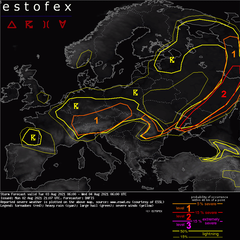
Storm Forecast
Valid: Tue 03 Aug 2021 06:00 to Wed 04 Aug 2021 06:00 UTC
Issued: Mon 02 Aug 2021 21:07
Forecaster: DAFIS
A level 1 was issued for parts of Central Europe mainly for severe convective wind gusts, large hail, and excessive precipitation.
SYNOPSIS
Europe will continue to be divided by extremely hot air masses in the SE and eastern parts and unseasonably cold air masses in the western and central parts. The zonal flow over the Mediterranean results in weak instability, almost all of it strongly capped.
The main synoptic feature during this outlook will be the elongated cold front of a low-pressure system with a center in E Scandinavia. The front extends between Scandinavia and the Black Sea, which will be the main area with DMC events. Another slow-moving low-pressure system will develop over Central Europe as a response to a middle-level shortwave trough. Several storms will develop in Central Europe in a low-CAPE / high-shear environment that creates many questions for CI and the potential severity of the storms.
... Central Europe ....
A short-wave trough is about to cross Central Europe with a high-vorticity blob. At the surface, rather low mixing ratios suggest that LCLs may be high, above 1000m, but saturated vertical profiles in the NWP models show a potential for flash floods during slow-moving storms. Locally steep lapse rates after the maximum diurnal heating will also increase the threat for large hail, mostly in N Italy, Austria and the Czech Republic. In addition, the belt of a westerly mid-level jet increases the threat for severe convective wind gusts.


 Gewitter im grenzgebiet Bayern innviertel N-flachgau mit starken Regen


